Quiéry-la-Motte
| Quiéry-la-Motte | ||
|---|---|---|
| Commune | ||
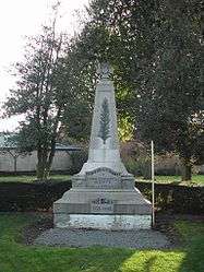 The monument to the dead of Quiéry-la-motte | ||
| ||
 Quiéry-la-Motte Location within Hauts-de-France region  Quiéry-la-Motte | ||
| Coordinates: 50°21′59″N 2°58′44″E / 50.3664°N 2.9789°ECoordinates: 50°21′59″N 2°58′44″E / 50.3664°N 2.9789°E | ||
| Country | France | |
| Region | Hauts-de-France | |
| Department | Pas-de-Calais | |
| Arrondissement | Arras | |
| Canton | Brebières | |
| Intercommunality | CC Osartis Marquion | |
| Government | ||
| • Mayor (2008–2014) | Jean-Luc Leroux | |
| Area1 | 8.93 km2 (3.45 sq mi) | |
| Population (2006)2 | 763 | |
| • Density | 85/km2 (220/sq mi) | |
| Time zone | UTC+1 (CET) | |
| • Summer (DST) | UTC+2 (CEST) | |
| INSEE/Postal code | 62680 /62490 | |
| Elevation |
26–64 m (85–210 ft) (avg. 32 m or 105 ft) | |
|
1 French Land Register data, which excludes lakes, ponds, glaciers > 1 km2 (0.386 sq mi or 247 acres) and river estuaries. 2 Population without double counting: residents of multiple communes (e.g., students and military personnel) only counted once. | ||

Quiéry-la-Motte is a commune in the Pas-de-Calais department in the Hauts-de-France region of France.
Geography
Quiéry-la-Motte is situated 12 miles (19 km) northeast of Arras, at the junction of the D39 and D48 roads. The A1 autoroute passes right by the commune.
Population
| 1962 | 1968 | 1975 | 1982 | 1990 | 1999 | 2006 |
|---|---|---|---|---|---|---|
| 563 | 568 | 673 | 701 | 769 | 775 | 763 |
| Census count starting from 1962: Population without duplicates | ||||||
Places of interest
See also
References
External links
| Wikimedia Commons has media related to Quiéry-la-Motte. |
- Official website of the commune (in French)
- Quiéry-la-Motte on the Quid website (in French)
This article is issued from
Wikipedia.
The text is licensed under Creative Commons - Attribution - Sharealike.
Additional terms may apply for the media files.