Mercatel
| Mercatel | ||
|---|---|---|
| Commune | ||
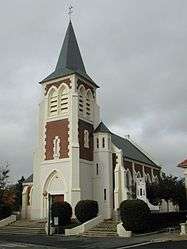 The church of Mercatel | ||
| ||
 Mercatel Location within Hauts-de-France region  Mercatel | ||
| Coordinates: 50°14′10″N 2°47′47″E / 50.2361°N 2.7964°ECoordinates: 50°14′10″N 2°47′47″E / 50.2361°N 2.7964°E | ||
| Country | France | |
| Region | Hauts-de-France | |
| Department | Pas-de-Calais | |
| Arrondissement | Arras | |
| Canton | Arras-3 | |
| Intercommunality | Communauté urbaine d'Arras | |
| Government | ||
| • Mayor (2008–2014) | Adrienne Crombez | |
| Area1 | 5.76 km2 (2.22 sq mi) | |
| Population (2006)2 | 640 | |
| • Density | 110/km2 (290/sq mi) | |
| Time zone | UTC+1 (CET) | |
| • Summer (DST) | UTC+2 (CEST) | |
| INSEE/Postal code | 62568 /62217 | |
| Elevation |
71–99 m (233–325 ft) (avg. 88 m or 289 ft) | |
|
1 French Land Register data, which excludes lakes, ponds, glaciers > 1 km2 (0.386 sq mi or 247 acres) and river estuaries. 2 Population without double counting: residents of multiple communes (e.g., students and military personnel) only counted once. | ||

Mercatel is a commune in the Pas-de-Calais department in the Hauts-de-France region of France.
Geography
Mercatel is situated 4 miles (6 km) south of Arras, at the junction of the D34 and the N17 roads.
Population
| 1962 | 1968 | 1975 | 1982 | 1990 | 1999 | 2006 |
|---|---|---|---|---|---|---|
| 436 | 446 | 526 | 515 | 546 | 572 | 640 |
| Census count starting from 1962: Population without duplicates | ||||||
Places of interest
- The church of St.Leger, rebuilt, as was most of the village, after the First World War.
- The Commonwealth War Graves Commission cemetery.
See also
References
External links
| Wikimedia Commons has media related to Mercatel. |
- The CWGC cemetery
- Mercatel on the Quid website (in French)
This article is issued from
Wikipedia.
The text is licensed under Creative Commons - Attribution - Sharealike.
Additional terms may apply for the media files.