Ransart, Pas-de-Calais
| Ransart | ||
|---|---|---|
| Commune | ||
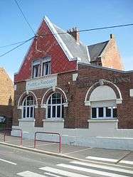 The town hall of Ransart | ||
| ||
 Ransart Location within Hauts-de-France region  Ransart | ||
| Coordinates: 50°12′36″N 2°41′12″E / 50.21°N 2.6867°E / 50.21; 2.6867Coordinates: 50°12′36″N 2°41′12″E / 50.21°N 2.6867°E / 50.21; 2.6867 | ||
| Country | France | |
| Region | Hauts-de-France | |
| Department | Pas-de-Calais | |
| Arrondissement | Arras | |
| Canton | Avesnes-le-Comte | |
| Intercommunality | CU Arras | |
| Government | ||
| • Mayor (2008–2014) | Betty Contart | |
| Area1 | 7.45 km2 (2.88 sq mi) | |
| Population (2006)2 | 381 | |
| • Density | 51/km2 (130/sq mi) | |
| Time zone | UTC+1 (CET) | |
| • Summer (DST) | UTC+2 (CEST) | |
| INSEE/Postal code | 62689 /62173 | |
| Elevation |
92–141 m (302–463 ft) (avg. 108 m or 354 ft) | |
|
1 French Land Register data, which excludes lakes, ponds, glaciers > 1 km2 (0.386 sq mi or 247 acres) and river estuaries. 2 Population without double counting: residents of multiple communes (e.g., students and military personnel) only counted once. | ||

Ransart is a commune in the Pas-de-Calais department in the Hauts-de-France region of France.
Geography
Ransart is situated 8 miles (13 km) southwest of Arras, at the junction of the D7 and D3 roads.
Population
| 1962 | 1968 | 1975 | 1982 | 1990 | 1999 | 2006 |
|---|---|---|---|---|---|---|
| 355 | 376 | 346 | 352 | 357 | 374 | 381 |
| Census count starting from 1962: Population without duplicates | ||||||
Places of interest
- The church of St.Laurent was rebuilt, as was much of the village, after World War I.
See also
References
External links
| Wikimedia Commons has media related to Ransart (Pas-de-Calais). |
- Ransart on the Quid website (in French)
| Authority control |
|---|
This article is issued from
Wikipedia.
The text is licensed under Creative Commons - Attribution - Sharealike.
Additional terms may apply for the media files.