Lépine, Pas-de-Calais
| Lépine | ||
|---|---|---|
| Commune | ||
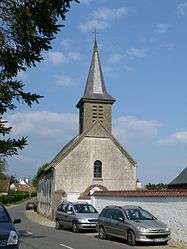 The church of Lépine | ||
| ||
 Lépine Location within Hauts-de-France region  Lépine | ||
| Coordinates: 50°22′43″N 1°43′37″E / 50.3786°N 1.7269°ECoordinates: 50°22′43″N 1°43′37″E / 50.3786°N 1.7269°E | ||
| Country | France | |
| Region | Hauts-de-France | |
| Department | Pas-de-Calais | |
| Arrondissement | Montreuil | |
| Canton | Berck | |
| Intercommunality | CA Deux Baies en Montreuillois | |
| Government | ||
| • Mayor | Frederic Carre | |
| Area1 | 10.82 km2 (4.18 sq mi) | |
| Population (2006)2 | 291 | |
| • Density | 27/km2 (70/sq mi) | |
| Time zone | UTC+1 (CET) | |
| • Summer (DST) | UTC+2 (CEST) | |
| INSEE/Postal code | 62499 /62170 | |
| Elevation |
3–59 m (9.8–193.6 ft) (avg. 46 m or 151 ft) | |
|
1 French Land Register data, which excludes lakes, ponds, glaciers > 1 km2 (0.386 sq mi or 247 acres) and river estuaries. 2 Population without double counting: residents of multiple communes (e.g., students and military personnel) only counted once. | ||

Lépine is a commune in the Pas-de-Calais department in the Hauts-de-France region of France.
Geography
Lépine is situated 6 miles (9 km) south of Montreuil-sur-Mer, just off the N1 on the D140 road.
Population
| Year | 1962 | 1968 | 1975 | 1982 | 1990 | 1999 | 2006 |
|---|---|---|---|---|---|---|---|
| Population | 271 | 319 | 268 | 279 | 296 | 297 | 291 |
| From the year 1962 on: No double counting—residents of multiple communes (e.g. students and military personnel) are counted only once. | |||||||
Places of interest
- The fifteenth century church of the Nativité-de-Notre-Dame.
- Château du Puits-Bérault, dating from the nineteenth century.
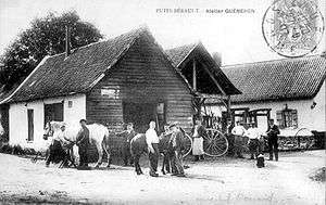
The farrier’s yard at Puits-Bérault, around 1905.
See also
References
External links
| Wikimedia Commons has media related to Lépine (Pas-de-Calais). |
- Lépine on the Quid website (in French)
This article is issued from
Wikipedia.
The text is licensed under Creative Commons - Attribution - Sharealike.
Additional terms may apply for the media files.