Blairville, Pas-de-Calais
| Blairville | ||
|---|---|---|
| Commune | ||
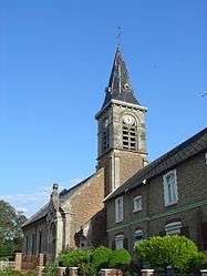 The church of Blairville | ||
| ||
 Blairville Location within Hauts-de-France region  Blairville | ||
| Coordinates: 50°13′14″N 2°42′53″E / 50.2206°N 2.7147°E / 50.2206; 2.7147Coordinates: 50°13′14″N 2°42′53″E / 50.2206°N 2.7147°E / 50.2206; 2.7147 | ||
| Country | France | |
| Region | Hauts-de-France | |
| Department | Pas-de-Calais | |
| Arrondissement | Arras | |
| Canton | Avesnes-le-Comte | |
| Intercommunality | CC Campagnes de l'Artois | |
| Government | ||
| • Mayor (2008–2014) | Daniel Deruy | |
| Area1 | 4.6 km2 (1.8 sq mi) | |
| Population (2009)2 | 300 | |
| • Density | 65/km2 (170/sq mi) | |
| Time zone | UTC+1 (CET) | |
| • Summer (DST) | UTC+2 (CEST) | |
| INSEE/Postal code | 62135 /62173 | |
| Elevation |
91–130 m (299–427 ft) (avg. 115 m or 377 ft) | |
|
1 French Land Register data, which excludes lakes, ponds, glaciers > 1 km2 (0.386 sq mi or 247 acres) and river estuaries. 2 Population without double counting: residents of multiple communes (e.g., students and military personnel) only counted once. | ||

Blairville is a commune in the Pas-de-Calais department in the Hauts-de-France region in northern France.
Geography
A farming village located 8 miles (13 km) southwest of Arras on the D34 road.
Population
| Historical population | ||
|---|---|---|
| Year | Pop. | ±% |
| 1962 | 240 | — |
| 1968 | 247 | +2.9% |
| 1975 | 269 | +8.9% |
| 1982 | 265 | −1.5% |
| 1990 | 271 | +2.3% |
| 1999 | 298 | +10.0% |
| 2009 | 300 | +0.7% |
Sights
- The church of St. Vaast, which, like most of the village, was rebuilt after the ravages of World War I.
See also
References
External links
| Wikimedia Commons has media related to Blairville. |
- Blairville on the Quid website (in French)
This article is issued from
Wikipedia.
The text is licensed under Creative Commons - Attribution - Sharealike.
Additional terms may apply for the media files.