Neuve-Chapelle
| Neuve-Chapelle | ||
|---|---|---|
| Commune | ||
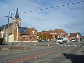 The centre of Neuve-Chapelle | ||
| ||
 Neuve-Chapelle Location within Hauts-de-France region  Neuve-Chapelle | ||
| Coordinates: 50°35′04″N 2°46′52″E / 50.5844°N 2.7811°ECoordinates: 50°35′04″N 2°46′52″E / 50.5844°N 2.7811°E | ||
| Country | France | |
| Region | Hauts-de-France | |
| Department | Pas-de-Calais | |
| Arrondissement | Béthune | |
| Canton | Beuvry | |
| Intercommunality | CA Béthune-Bruay, Artois-Lys Romane | |
| Government | ||
| • Mayor (2008–2014) | Maurice Morel | |
| Area1 | 1.86 km2 (0.72 sq mi) | |
| Population (2006)2 | 1,374 | |
| • Density | 740/km2 (1,900/sq mi) | |
| Time zone | UTC+1 (CET) | |
| • Summer (DST) | UTC+2 (CEST) | |
| INSEE/Postal code | 62606 /62840 | |
| Elevation |
17–20 m (56–66 ft) (avg. 19 m or 62 ft) | |
|
1 French Land Register data, which excludes lakes, ponds, glaciers > 1 km2 (0.386 sq mi or 247 acres) and river estuaries. 2 Population without double counting: residents of multiple communes (e.g., students and military personnel) only counted once. | ||

Neuve-Chapelle is a commune in the Pas-de-Calais department in the Hauts-de-France region of France. It was the site of a First World War battle in 1915.
Geography
Neuve-Chapelle is situated some 8 miles (12.9 km) northeast of Béthune and 16 miles (25.7 km) southwest of Lille, near the junction of the D947 and D171 roads.
History
The village gave its name to a battle of the First World War that began on 10 March 1915, and in which it was captured, not for the first time, by the IV and I Indian Corps. It was later adopted by the County Borough of Blackpool and was awarded the Croix de Guerre in 1922.
Population
| 1962 | 1968 | 1975 | 1982 | 1990 | 1999 | 2006 |
|---|---|---|---|---|---|---|
| 440 | 462 | 471 | 548 | 864 | 958 | 1374 |
| Census count starting from 1962: Population without duplicates | ||||||
Places of interest
- The church of St. Christophe, rebuilt, as was much of the commune, after World War I.
- The Commonwealth War Graves Commission cemeteries and memorials.
- The Neuve-Chapelle Indian Memorial of the British Indian Army.
- Finds from the battlefield, in the mairie.
See also
References
External links
| Wikimedia Commons has media related to Neuve-Chapelle. |
- Website about the battle of Neuve-Chapelle
- The CWGC Indian memorial
- Neuve-Chapelle Farm CWGC cemetery
- The CWGC British cemetery
- The war memorial (in French)
- Neuve-Chapelle on the Quid website (in French)
- NB — All maplinks can be found by clicking on the coordinates link at the top of the page.
| Authority control |
|---|
This article is issued from
Wikipedia.
The text is licensed under Creative Commons - Attribution - Sharealike.
Additional terms may apply for the media files.