Hermaville
| Hermaville | ||
|---|---|---|
| Commune | ||
 An aerial view of Hermaville | ||
| ||
 Hermaville Location within Hauts-de-France region  Hermaville | ||
| Coordinates: 50°19′24″N 2°35′14″E / 50.3233°N 2.5872°ECoordinates: 50°19′24″N 2°35′14″E / 50.3233°N 2.5872°E | ||
| Country | France | |
| Region | Hauts-de-France | |
| Department | Pas-de-Calais | |
| Arrondissement | Arras | |
| Canton | Avesnes-le-Comte | |
| Intercommunality | CC Campagnes de l'Artois | |
| Government | ||
| • Mayor (2008–2014) | Michel Accart | |
| Area1 | 6.32 km2 (2.44 sq mi) | |
| Population (2006)2 | 536 | |
| • Density | 85/km2 (220/sq mi) | |
| Time zone | UTC+1 (CET) | |
| • Summer (DST) | UTC+2 (CEST) | |
| INSEE/Postal code | 62438 /62690 | |
| Elevation |
85–142 m (279–466 ft) (avg. 94 m or 308 ft) | |
|
1 French Land Register data, which excludes lakes, ponds, glaciers > 1 km2 (0.386 sq mi or 247 acres) and river estuaries. 2 Population without double counting: residents of multiple communes (e.g., students and military personnel) only counted once. | ||

Hermaville is a commune in the Pas-de-Calais department in the Hauts-de-France region of France.
Geography
A farming village situated 8 miles (13 km) west of Arras, at the junction of the D54 and the D74 roads.
Population
| Year | 1962 | 1968 | 1975 | 1982 | 1990 | 1999 | 2006 |
|---|---|---|---|---|---|---|---|
| Population | 315 | 329 | 313 | 402 | 456 | 455 | 536 |
| From the year 1962 on: No double counting—residents of multiple communes (e.g. students and military personnel) are counted only once. | |||||||
Places of interest
- The church of St. Georges, dating from the seventeenth century.
- The chateau, dating from the eighteenth century.
- Traces of an old castle, destroyed in 1640 by the French.
See also
References
External links
| Wikimedia Commons has media related to Hermaville. |
- Commune website
- Hermaville on the Quid website (in French)
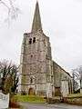 Saint Georges church in winter
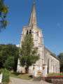 The church in summer
 A niche over the church porch
 Unusual features on the spire
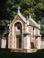 The Salignac-Fénelon family crypt
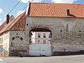 The farm of Saint Georges
 The village hall
This article is issued from
Wikipedia.
The text is licensed under Creative Commons - Attribution - Sharealike.
Additional terms may apply for the media files.