Hauts-de-France
| Hauts-de-France | |
|---|---|
| Region | |
 | |
| Country |
|
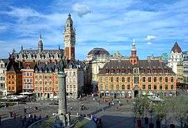
| Prefecture | Lille |
| Departments | |
| Government | |
| • President | Xavier Bertrand (DVD) |
| Area | |
| • Total | 31,813 km2 (12,283 sq mi) |
| Population (2012) | |
| • Total | 5,973,098 |
| • Density | 190/km2 (490/sq mi) |
| Time zone | UTC+1 (CET) |
| • Summer (DST) | UTC+2 (CEST) |
| ISO 3166 code | FR-HDF |
| NUTS Region | FRE |
| Website |
www |
Hauts-de-France[1] (French pronunciation: [o d(ə) fʁɑ̃s], translates to "Upper France" in English; Picard: Heuts-d'Franche) is a region of France created by the territorial reform of French Regions in 2014, from a merger of Nord-Pas-de-Calais and Picardy. The new region came into existence on 1 January 2016, after the regional elections in December 2015.[2] France's Conseil d'État approved Hauts-de-France as the name of the region on 28 September 2016, effective 30 September 2016.[3]
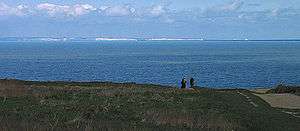
The region covers an area of more than 31,813 km2 (12,283 sq mi), and has a population of 5,973,098.[4] It borders Normandy, Grand Est, Île-de-France, Belgium (Flemish Region and Wallonia) and the United Kingdom via the English Channel.
Toponymy
The region's interim name Nord-Pas-de-Calais-Picardie was a hyphenated placename, created by hyphenating the merged regions' names—Nord-Pas-de-Calais and Picardie—in alphabetical order.[5]
On 14 March 2016, well ahead of the 1 July deadline, the Regional council decided on Hauts-de-France as the region's permanent name.[1][5] The provisional name of the region was retired on 30 September 2016, when the new name of the region, Hauts-de-France, took effect.[3]
Geography
The region borders Belgium (Flanders and Wallonia) to the northeast, the English Channel to the northwest, as well as the French regions of Grand Est to the southeast, Île-de-France to the south, and Normandy to the southwest. It is connected to the United Kingdom (England) via the Channel Tunnel.
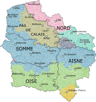
Departments
Hauts-de-France comprises five departments: Aisne, Nord, Oise, Pas-de-Calais, and Somme.
Major communities
.JPG)
- Lille (227,560; region prefecture)
- Amiens (133,448)
- Roubaix (94,713)
- Tourcoing (91,923)
- Dunkirk (90,995)
- Calais (72,589)
- Villeneuve-d'Ascq (62,308)
- Saint-Quentin (55,978)
- Beauvais (54,289)
- Valenciennes (42,691)
See also
References
- 1 2 "La Région a voté et s'appelle désormais Hauts-de-France" [The region has voted and is now called Hauts-de-France]. La Voix du Nord (in French). Lille. 15 March 2016. Retrieved 15 March 2016.
- ↑ "La carte à 13 régions définitivement adoptée" [The 13-region map finally adopted]. Le Monde (in French). Agence France-Presse. 17 December 2014. Retrieved 13 January 2015.
- 1 2 Décret n° 2016-1265 du 28 septembre 2016 portant fixation du nom et du chef-lieu de la région Hauts-de-France (in French)
- ↑ "Populations légales 2012 - Populations légales des régions". Insee. Retrieved 16 January 2015.
- 1 2 Loi n° 2015-29 du 16 janvier 2015 relative à la délimitation des régions, aux élections régionales et départementales et modifiant le calendrier électoral (in French)
External links
| Wikivoyage has a travel guide for Hauts-de-France. |
- Official website

- Merger of the regions - France 3