Wirwignes
| Wirwignes | ||
|---|---|---|
| Commune | ||
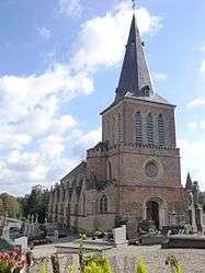 The church of Wirwignes | ||
| ||
 Wirwignes Location within Hauts-de-France region  Wirwignes | ||
| Coordinates: 50°41′09″N 1°45′43″E / 50.6858°N 1.7619°ECoordinates: 50°41′09″N 1°45′43″E / 50.6858°N 1.7619°E | ||
| Country | France | |
| Region | Hauts-de-France | |
| Department | Pas-de-Calais | |
| Arrondissement | Boulogne-sur-Mer | |
| Canton | Desvres | |
| Intercommunality | CC Desvres-Samer | |
| Government | ||
| • Mayor (2014-2020) | Philippe Leleu | |
| Area1 | 12.47 km2 (4.81 sq mi) | |
| Population (2014)2 | 740 | |
| • Density | 59/km2 (150/sq mi) | |
| Time zone | UTC+1 (CET) | |
| • Summer (DST) | UTC+2 (CEST) | |
| INSEE/Postal code | 62896 /62240 | |
| Elevation |
22–102 m (72–335 ft) (avg. 28 m or 92 ft) | |
|
1 French Land Register data, which excludes lakes, ponds, glaciers > 1 km2 (0.386 sq mi or 247 acres) and river estuaries. 2 Population without double counting: residents of multiple communes (e.g., students and military personnel) only counted once. | ||

Wirwignes is a commune in the Pas-de-Calais department in the Hauts-de-France region of France.
Geography
Wirwignes is situated some 8 miles (13 km) southeast of Boulogne, at the junction of the D238 and the D341 roads, on the banks of the river Liane.
Population
| Year | 1962 | 1968 | 1975 | 1982 | 1990 | 1999 | 2006 |
|---|---|---|---|---|---|---|---|
| Population | 484 | 507 | 492 | 528 | 638 | 682 | 704 |
| From the year 1962 on: No double counting—residents of multiple communes (e.g. students and military personnel) are counted only once. | |||||||
Places of interest
- The church of St.Quentin, dating from the fifteenth century.
- The château de Quenneval, dating from the seventeenth century.
- A seventeenth century fortified manorhouse.
See also
References
External links
| Wikimedia Commons has media related to Wirwignes. |
- Wirwignes on the Quid website (in French)
This article is issued from
Wikipedia.
The text is licensed under Creative Commons - Attribution - Sharealike.
Additional terms may apply for the media files.