Liévin
| Liévin | ||
|---|---|---|
| Commune | ||
.JPG) The church of Saint-Amé of the mines of Lens, in Liévin | ||
| ||
 Liévin Location within Hauts-de-France region  Liévin | ||
| Coordinates: 50°25′22″N 2°46′43″E / 50.4228°N 2.7786°ECoordinates: 50°25′22″N 2°46′43″E / 50.4228°N 2.7786°E | ||
| Country | France | |
| Region | Hauts-de-France | |
| Department | Pas-de-Calais | |
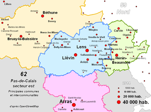
| Arrondissement | Lens | |
| Canton | Liévin | |
| Intercommunality | CA Lens-Liévin | |
| Government | ||
| • Mayor (2013–2020) | Laurent Duporge | |
| Area1 | 12.83 km2 (4.95 sq mi) | |
| Population (2006)2 | 33,022 | |
| • Density | 2,600/km2 (6,700/sq mi) | |
| Time zone | UTC+1 (CET) | |
| • Summer (DST) | UTC+2 (CEST) | |
| INSEE/Postal code | 62510 /62800 | |
| Elevation | 32–80 m (105–262 ft) | |
|
1 French Land Register data, which excludes lakes, ponds, glaciers > 1 km2 (0.386 sq mi or 247 acres) and river estuaries. 2 Population without double counting: residents of multiple communes (e.g., students and military personnel) only counted once. | ||

Liévin (French pronunciation: [ljevɛ̃]; Picard: Lévin) is a commune in the Pas-de-Calais department in northern France. The inhabitants are called Liévinois.
Overview
The town of Liévin is an old mining area of Pas-de-Calais. Near Lens, this town is of modest size but has several nursery schools, schools, colleges, a university, a swimming pool, a city library, a cultural and social center (CCS), a hospital, a covered stadium, several gardens and parks, two movie theaters, two cemeteries, a Catholic church, a shopping center, a National Police station, a fire station, a complete intercommunity transportation system (Tadao ), regional newspapers, the main ones being L'Avenir de l'Artois [the Future of Artois], La Voix du Nord (Voice of the North) and Nord Éclair (Northern Flash), etc. The city has also recently acquired ADSL connectivity.
Administration
Liévin is the seat of two cantons. It belongs to the Agglomeration community of Lens – Liévin) which consists of 36 communes, with a total population of 250,000 inhabitants.
History
Prehistory
The history of Liévin begins in ancient times. The foothill of Riaumont (highest point in Liévin) is a rich archaeological site. Traces of Neolithic and Gallo-Roman periods have been found there, and 752 tombs attest that Liévin was once a Merovingian burial ground.
Agriculture and mining
In 1414, there were barely 150 inhabitants in Liévin. At that time, it was a village mainly concerned with agriculture. The population grew steadily until the First World War.
- 600 inhabitants in 1759
- 900 inhabitants in 1789
- 1223 inhabitants in 1820
Coal was discovered in the vicinity of Lens, Pas-de-Calais in 1849, and near Liévin in 1857. This precipitated a time of great productivity, prosperity, and population growth. The population of Liévin was 25,698 in 1914.
During the World Wars
The First World War brutally ended Liévin's expansion. The city was ruined, the churches and castles destroyed. Human losses were 400 civilian and 600 military. The city of Liévin was awarded the Croix de Guerre in 1920.
After the war, it was necessary to rebuild everything. After a few years, Liévin was again an active city, and mining recommenced. In 1936, the nearby (5.6 km) Canadian National Vimy Memorial was dedicated to the Battle of Vimy Ridge (part of the Battle of Arras) and the Canadian forces killed during the First World War; it is also the site of two WWI Canadian cemeteries.[1]
World War II again stopped the progress of the city. In 1940, Liévin was evacuated, and the city was settled by Germans. Resistance was organized, in particular with the help of the Voix du Nord newspaper. In this war, there were 220 civilian and 225 military casualties. Liévin was liberated on 2 September 1944 by the British Eighth Army.
After the war, mining recommenced in force; coal mining was vital to the reconstruction of the French economy. Silicosis, which would kill many miners, made its appearance.
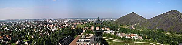
End of coal mining
In addition to silicosis, miners were in daily peril of being lost in mining catastrophes. There were five major mining catastrophes during the coal mining period:
- 28 November 1861, pit 1, 2 dead
- 13 August 1882, pit 3, 8 dead
- 14 January 1885, pit 1, 28 dead
- 16 March 1957, pit 3, 10 dead
- 27 December 1974, Saint-Amé pit, 42 dead
Additionally, a recession in the mining industry began and with it a recession in Liévin. From 1960 to 1970, 60 of the 67 pits closed, Following the tragedy in Saint-Amé, the last coal mining pit closed in 1974. Liévin no longer produces coal, and has moved on to a new chapter.
Liévin without coal
Liévin suffered a great deal when coal mining was abandoned, since it had depended primarily on the mines. The city converted to other industries. While it may not have the same economic dynamism of the earlier epoch, the commercial and industrial areas are a source of employment for many, and the city remains relatively prosperous with 33,430 inhabitants (see above).
Mayors of Liévin since the French Revolution
- 1790–1810, Procope-Alexandre-Joseph de Ligne
- 1810–1819, Pierre Caron
- 1820–1822, Jacques Delaby
- 1822–1825, Pierre Caron
- 1825–1856, Henri-Antoine de Ligne
- 1856–1871, Nicolas Antoine Delaby
- 1871–1878, Alexandre-Procope Comte Jonglez de Ligne
- 1879–1892, Louis Schmidt
- 1892, Félix Pamart
- 1893–1905, Edouard Defernez
- 1905–1912, Arthur Lamendin
- 1912–1913, Pierre Leroy
- 1914, François Pouvier
- 1914–1919 : (evacuation)
- 1919–1925, Léon Degreaux
- 1925–1929, Jules Bédart
- 1930–1935, Silas Goulet
- 1936–1939, Henri-Joseph Thiébaut
- 1939–1944, Louis Thobois
- 1944–1945, Henri Bertin
- 1945–1947, Florimond Lemaire
- 1947–1952, Eugène Gossart
- 1952–1981, Henri Darras
- 1981–2013, Jean-Pierre Kucheida
- 2013–present, Laurent Duporge
Notable people
Famous people from Liévin include:
- Georges Carpentier (boxer)
- Robert Enrico (film director)
International relations
Twin towns – Sister cities
Liévin is twinned with:
|
|
References
- Notes
- ↑ "Canadian National Vimy Memorial, France". The Great War UK. The Great War UK. 2015. Retrieved 31 March 2017.
The ridge runs in a direction from Givenchy-en-Gohelle in the north-west to Farbus in the south-east.
- ↑ "Rybnik Official Website – Twin Towns".

- ↑ "Miasta partnerskie i zaprzyjaźnione Nowego Sącza". Urząd Miasta Nowego Sącza (in Polish). Archived from the original on 2013-05-23. Retrieved 2013-08-01.
External links
| Wikimedia Commons has media related to Liévin. |
- Town council website (in French)