Estrée
| Estrée | ||
|---|---|---|
| Commune | ||
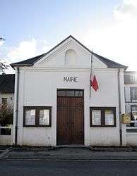 The town hall of Estrée | ||
| ||
 Estrée Location within Hauts-de-France region  Estrée | ||
| Coordinates: 50°30′00″N 1°47′26″E / 50.5°N 1.7906°ECoordinates: 50°30′00″N 1°47′26″E / 50.5°N 1.7906°E | ||
| Country | France | |
| Region | Hauts-de-France | |
| Department | Pas-de-Calais | |
| Arrondissement | Montreuil | |
| Canton | Berck | |
| Intercommunality | CA Deux Baies en Montreuillois | |
| Government | ||
| • Mayor (2001–2008) | Daniel Jumez | |
| Area1 | 4.47 km2 (1.73 sq mi) | |
| Population (1999)2 | 276 | |
| • Density | 62/km2 (160/sq mi) | |
| Time zone | UTC+1 (CET) | |
| • Summer (DST) | UTC+2 (CEST) | |
| INSEE/Postal code | 62312 /62170 | |
| Elevation |
6–116 m (20–381 ft) (avg. 13 m or 43 ft) | |
|
1 French Land Register data, which excludes lakes, ponds, glaciers > 1 km2 (0.386 sq mi or 247 acres) and river estuaries. 2 Population without double counting: residents of multiple communes (e.g., students and military personnel) only counted once. | ||
.svg.png)
Estrée is a commune in the Pas-de-Calais department in the Hauts-de-France region of France.
Geography
A village situated some 3 miles (5 km) northeast of Montreuil-sur-Mer at the D127 road.
It is one of many villages in the north of France bearing the name Estrées. The etymology of the name is from strata (cognate of English "street"), the word for the stone-layered Roman roads in the area (some of which turned into modern highways). Hence Estreti, village on the road which developed into Estrées.
Population
| Year | 1962 | 1968 | 1975 | 1982 | 1990 | 1999 |
|---|---|---|---|---|---|---|
| Population | 152 | 155 | 137 | 237 | 274 | 276 |
| From the year 1962 on: No double counting—residents of multiple communes (e.g. students and military personnel) are counted only once. | ||||||
Places of interest
- The nineteenth century church of Saint Omer
See also
References
External links
| Wikimedia Commons has media related to Estrée. |
- Estrée on the Quid website (in French)
This article is issued from
Wikipedia.
The text is licensed under Creative Commons - Attribution - Sharealike.
Additional terms may apply for the media files.