Haut-Loquin
| Haut-Loquin | ||
|---|---|---|
| Commune | ||
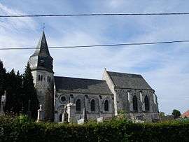 The church of Haut-Loquin | ||
| ||
 Haut-Loquin Location within Hauts-de-France region  Haut-Loquin | ||
| Coordinates: 50°44′26″N 1°58′06″E / 50.7406°N 1.9683°ECoordinates: 50°44′26″N 1°58′06″E / 50.7406°N 1.9683°E | ||
| Country | France | |
| Region | Hauts-de-France | |
| Department | Pas-de-Calais | |
| Arrondissement | Saint-Omer | |
| Canton | Lumbres | |
| Intercommunality | Pays de Lumbres | |
| Government | ||
| • Mayor | Gilbert Regnault | |
| Area1 | 5.47 km2 (2.11 sq mi) | |
| Population (1999)2 | 133 | |
| • Density | 24/km2 (63/sq mi) | |
| Time zone | UTC+1 (CET) | |
| • Summer (DST) | UTC+2 (CEST) | |
| INSEE/Postal code | 62419 /62850 | |
| Elevation |
78–210 m (256–689 ft) (avg. 110 m or 360 ft) | |
|
1 French Land Register data, which excludes lakes, ponds, glaciers > 1 km2 (0.386 sq mi or 247 acres) and river estuaries. 2 Population without double counting: residents of multiple communes (e.g., students and military personnel) only counted once. | ||

Haut-Loquin is a commune in the Pas-de-Calais department in the Hauts-de-France region of France.
Geography
A small village situated 11 miles (18 km) west of Saint-Omer, on the D216 road.
Population
| Year | 1962 | 1968 | 1975 | 1982 | 1990 | 1999 |
|---|---|---|---|---|---|---|
| Population | 156 | 164 | 149 | 151 | 145 | 133 |
| From the year 1962 on: No double counting—residents of multiple communes (e.g. students and military personnel) are counted only once. | ||||||
Places of interest
- The church of St.Peter, dating from the eleventh century.
See also
References
External links
| Wikimedia Commons has media related to Haut-Loquin. |
- Haut-Loquin on the Insee website (in French)
- Haut-Loquin on the Quid website (in French)
This article is issued from
Wikipedia.
The text is licensed under Creative Commons - Attribution - Sharealike.
Additional terms may apply for the media files.