Peuplingues
| Peuplingues | ||
|---|---|---|
| Commune | ||
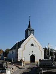 The church of Peuplingues | ||
| ||
 Peuplingues Location within Hauts-de-France region  Peuplingues | ||
| Coordinates: 50°54′56″N 1°46′05″E / 50.9156°N 1.7681°ECoordinates: 50°54′56″N 1°46′05″E / 50.9156°N 1.7681°E | ||
| Country | France | |
| Region | Hauts-de-France | |
| Department | Pas-de-Calais | |
| Arrondissement | Calais | |
| Canton | Calais-1 | |
| Intercommunality | CC Pays d'Opale | |
| Government | ||
| • Mayor (2008–2014) | Richard Gosse | |
| Area1 | 10.43 km2 (4.03 sq mi) | |
| Population (2006)2 | 622 | |
| • Density | 60/km2 (150/sq mi) | |
| Time zone | UTC+1 (CET) | |
| • Summer (DST) | UTC+2 (CEST) | |
| INSEE/Postal code | 62654 /62231 | |
| Elevation |
11–137 m (36–449 ft) (avg. 85 m or 279 ft) | |
|
1 French Land Register data, which excludes lakes, ponds, glaciers > 1 km2 (0.386 sq mi or 247 acres) and river estuaries. 2 Population without double counting: residents of multiple communes (e.g., students and military personnel) only counted once. | ||

Peuplingues is a commune in the Pas-de-Calais department in the Hauts-de-France region of France.
Geography
Peuplingues is located 5 miles (8 km) southwest of Calais, at the junction of the D243 and D243E roads, about a mile from the A16 autoroute. The French portal of the Channel Tunnel is physically located in Peuplingues.
Population
| 1962 | 1968 | 1975 | 1982 | 1990 | 1999 | 2006 |
|---|---|---|---|---|---|---|
| 436 | 449 | 409 | 480 | 537 | 586 | 622 |
| Census count starting from 1962: Population without duplicates | ||||||
Places of interest
- The church of Notre-Dame dating from the seventeenth century.
See also
References
External links
| Wikimedia Commons has media related to Peuplingues. |
- Peuplingues on the Quid website (in French)
This article is issued from
Wikipedia.
The text is licensed under Creative Commons - Attribution - Sharealike.
Additional terms may apply for the media files.