Puisieux, Pas-de-Calais
| Puisieux | ||
|---|---|---|
| Commune | ||
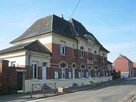 The town hall of Puisieux | ||
| ||
 Puisieux Location within Hauts-de-France region  Puisieux | ||
| Coordinates: 50°07′00″N 2°41′44″E / 50.1167°N 2.6956°ECoordinates: 50°07′00″N 2°41′44″E / 50.1167°N 2.6956°E | ||
| Country | France | |
| Region | Hauts-de-France | |
| Department | Pas-de-Calais | |
| Arrondissement | Arras | |
| Canton | Avesnes-le-Comte | |
| Intercommunality | CC Sud-Artois | |
| Government | ||
| • Mayor (2008–2014 - 2016) | Denis Grossemy | |
| Area1 | 11.69 km2 (4.51 sq mi) | |
| Population (2006)2 | 633 | |
| • Density | 54/km2 (140/sq mi) | |
| Time zone | UTC+1 (CET) | |
| • Summer (DST) | UTC+2 (CEST) | |
| INSEE/Postal code | 62672 /62116 | |
| Elevation |
77–147 m (253–482 ft) (avg. 128 m or 420 ft) | |
|
1 French Land Register data, which excludes lakes, ponds, glaciers > 1 km2 (0.386 sq mi or 247 acres) and river estuaries. 2 Population without double counting: residents of multiple communes (e.g., students and military personnel) only counted once. | ||

Puisieux or Puisieux-au-Mont is a commune in the Pas-de-Calais department in the Hauts-de-France region of France.
Geography
Puisieux is situated 14 miles (23 km) south of Arras, at the junction of the D919, D27 and D6 roads.
Population
| 1962 | 1968 | 1975 | 1982 | 1990 | 1999 | 2006 |
|---|---|---|---|---|---|---|
| 566 | 629 | 599 | 658 | 613 | 609 | 633 |
| Census count starting from 1962: Population without duplicates | ||||||
Places of interest
- The church of St.Denis, rebuilt, as was the rest of the village, after the First World War.
- The Commonwealth War Graves Commission cemeteries.
- A war memorial.
See also
References
External links
| Wikimedia Commons has media related to Puisieux (Pas-de-Calais). |
- Serre Road CWGC cemetery No. 3
- Serre Road CWGC cemetery No. 2
- Serre Road CWGC cemetery No. 1
- The Queens CWGC cemetery
- The CWGC communal cemetery
- Puisieux on the Quid website (in French)
This article is issued from
Wikipedia.
The text is licensed under Creative Commons - Attribution - Sharealike.
Additional terms may apply for the media files.