Saint-Aubin, Pas-de-Calais
| Saint-Aubin | ||
|---|---|---|
| Commune | ||
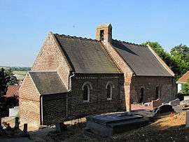 The church of Saint-Aubin | ||
| ||
 Saint-Aubin Location within Hauts-de-France region  Saint-Aubin | ||
| Coordinates: 50°27′27″N 1°40′00″E / 50.4575°N 1.6667°ECoordinates: 50°27′27″N 1°40′00″E / 50.4575°N 1.6667°E | ||
| Country | France | |
| Region | Hauts-de-France | |
| Department | Pas-de-Calais | |
| Arrondissement | Montreuil | |
| Canton | Étaples | |
| Intercommunality | CA Deux Baies en Montreuillois | |
| Government | ||
| • Mayor | Bertrand Lefebvre | |
| Area1 | 4.54 km2 (1.75 sq mi) | |
| Population (2006)2 | 252 | |
| • Density | 56/km2 (140/sq mi) | |
| Time zone | UTC+1 (CET) | |
| • Summer (DST) | UTC+2 (CEST) | |
| INSEE/Postal code | 62742 /62170 | |
| Elevation |
3–61 m (9.8–200.1 ft) (avg. 18 m or 59 ft) | |
|
1 French Land Register data, which excludes lakes, ponds, glaciers > 1 km2 (0.386 sq mi or 247 acres) and river estuaries. 2 Population without double counting: residents of multiple communes (e.g., students and military personnel) only counted once. | ||

Saint-Aubin is a commune in the Pas-de-Calais department in the Hauts-de-France region of France that won silver prize in the Entente Florale in 2000.[1]
Geography
Saint-Aubin is located 5 miles (8 km) west of Montreuil-sur-Mer on the D144E1 road.
Population
| 1962 | 1968 | 1975 | 1982 | 1990 | 1999 | 2006 |
|---|---|---|---|---|---|---|
| 113 | 123 | 124 | 191 | 197 | 217 | 252 |
| Census count starting from 1962: Population without duplicates | ||||||
Places of interest
- The church of St.Aubin, dating from the seventeenth century
- An eighteenth-century dovecote
See also
References
- ↑ "Nos jardiniers ont du talent !" (PDF). Retrieved 30 May 2012.
External links
| Wikimedia Commons has media related to Saint-Aubin (Pas-de-Calais). |
- Saint-Aubin on the Quid website (in French)
- INSEE commune file
| Authority control |
|---|
This article is issued from
Wikipedia.
The text is licensed under Creative Commons - Attribution - Sharealike.
Additional terms may apply for the media files.