Audincthun
| Audincthun | ||
|---|---|---|
| Commune | ||
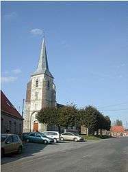 The church of Audincthun | ||
| ||
 Audincthun Location within Hauts-de-France region  Audincthun | ||
| Coordinates: 50°35′10″N 2°08′20″E / 50.5861°N 2.1389°ECoordinates: 50°35′10″N 2°08′20″E / 50.5861°N 2.1389°E | ||
| Country | France | |
| Region | Hauts-de-France | |
| Department | Pas-de-Calais | |
| Arrondissement | Saint-Omer | |
| Canton | Fruges | |
| Intercommunality | Pays de Saint-Omer | |
| Government | ||
| • Mayor (2014-2020) | Casimir Hochart | |
| Area1 | 15.26 km2 (5.89 sq mi) | |
| Population (2015)2 | 649 | |
| • Density | 43/km2 (110/sq mi) | |
| Time zone | UTC+1 (CET) | |
| • Summer (DST) | UTC+2 (CEST) | |
| INSEE/Postal code | 62053 /62560 | |
| Elevation |
64–183 m (210–600 ft) (avg. 64 m or 210 ft) | |
|
1 French Land Register data, which excludes lakes, ponds, glaciers > 1 km2 (0.386 sq mi or 247 acres) and river estuaries. 2 Population without double counting: residents of multiple communes (e.g., students and military personnel) only counted once. | ||

Audincthun is a commune in the Pas-de-Calais department in northern France.
Geography
A town located 20 miles (32 km) northeast of Montreuil-sur-Mer, at the junction of the D92 with the D133 road.
Population
| Historical population | ||
|---|---|---|
| Year | Pop. | ±% |
| 1962 | 543 | — |
| 1968 | 555 | +2.2% |
| 1975 | 543 | −2.2% |
| 1982 | 563 | +3.7% |
| 1990 | 578 | +2.7% |
| 1999 | 574 | −0.7% |
| 2009 | 666 | +16.0% |
| 2015 | 649 | −2.6% |
Personalities
- Albert de Dion, French automobile manufacturer (de Dion-Bouton), is buried in the family vault here.
Sights
- The fifteenth century church of St. Pierre.
- The eighteenth century church of St. Nicholas.
- The Sainte-Soyette Chapel.
- A line of 13 wind turbines are on the hills above the commune.
See also
References
External links
| Wikimedia Commons has media related to Audincthun. |
- Audincthun on the Quid website (in French)
This article is issued from
Wikipedia.
The text is licensed under Creative Commons - Attribution - Sharealike.
Additional terms may apply for the media files.