Thélus
| Thélus | ||
|---|---|---|
| Commune | ||
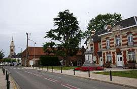 The centre of Thélus | ||
| ||
 Thélus Location within Hauts-de-France region  Thélus | ||
| Coordinates: 50°21′20″N 2°48′05″E / 50.3556°N 2.8014°ECoordinates: 50°21′20″N 2°48′05″E / 50.3556°N 2.8014°E | ||
| Country | France | |
| Region | Hauts-de-France | |
| Department | Pas-de-Calais | |
| Arrondissement | Arras | |
| Canton | Arras-2 | |
| Intercommunality | Arras | |
| Government | ||
| • Mayor (2008–2014) | Bernard Milleville | |
| Area1 | 8.99 km2 (3.47 sq mi) | |
| Population (2006)2 | 1,204 | |
| • Density | 130/km2 (350/sq mi) | |
| Time zone | UTC+1 (CET) | |
| • Summer (DST) | UTC+2 (CEST) | |
| INSEE/Postal code | 62810 /62580 | |
| Elevation |
88–143 m (289–469 ft) (avg. 121 m or 397 ft) | |
|
1 French Land Register data, which excludes lakes, ponds, glaciers > 1 km2 (0.386 sq mi or 247 acres) and river estuaries. 2 Population without double counting: residents of multiple communes (e.g., students and military personnel) only counted once. | ||

Thélus is a commune in the Pas-de-Calais department in the Hauts-de-France region of France. It is located 4 kilometres (2.5 mi) southeast of the Canadian National Vimy Memorial dedicated to the Battle of Vimy Ridge and the missing First World War Canadian soldiers with no known grave; the Memorial is also the site of two Canadian cemeteries.[1]
Geography
Thélus lies 5 miles (8.0 km) north of Arras, at the junction of the N17 and D49 roads. Junction 7 of the A26 autoroute is less than a mile away.
Population
| 1962 | 1968 | 1975 | 1982 | 1990 | 1999 | 2006 |
|---|---|---|---|---|---|---|
| 659 | 703 | 853 | 887 | 998 | 1022 | 1204 |
| Census count starting in 1962: Population without duplicates | ||||||
Places of interest
- The church of St.Ranulphe, rebuilt, as was most of the village, after World War I.
- Two memorials to the Canadians who fell during the First World War.
- The Commonwealth War Graves Commission cemeteries.
See also
References
- ↑ "Canadian National Vimy Memorial, France". The Great War UK. The Great War UK. 2015. Retrieved 31 March 2017.
The ridge runs in a direction from Givenchy-en-Gohelle in the north-west to Farbus in the south-east.
External links
| Wikimedia Commons has media related to Thélus. |
- Nine Elms CWGC cemetery
- Zivy Crater CWGC cemetery
- Lichfield Crater CWGC cemetery
- Bois-Carré CWGC cemetery
- The CWGC military cemetery at Thélus
- The communal cemetery
- Thélus on the Quid website (in French)
| Authority control |
|---|
This article is issued from
Wikipedia.
The text is licensed under Creative Commons - Attribution - Sharealike.
Additional terms may apply for the media files.