Salperwick
| Salperwick | ||
|---|---|---|
| Commune | ||
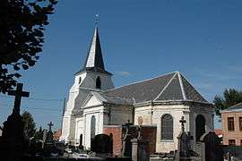 The church of Salperwick | ||
| ||
 Salperwick Location within Hauts-de-France region  Salperwick | ||
| Coordinates: 50°46′24″N 2°13′58″E / 50.7733°N 2.2328°ECoordinates: 50°46′24″N 2°13′58″E / 50.7733°N 2.2328°E | ||
| Country | France | |
| Region | Hauts-de-France | |
| Department | Pas-de-Calais | |
| Arrondissement | Saint-Omer | |
| Canton | Saint-Omer | |
| Intercommunality | Pays de Saint-Omer | |
| Government | ||
| • Mayor | Michel Martinot | |
| Area1 | 4 km2 (2 sq mi) | |
| Population (2013)2 | 511 | |
| • Density | 130/km2 (330/sq mi) | |
| Time zone | UTC+1 (CET) | |
| • Summer (DST) | UTC+2 (CEST) | |
| INSEE/Postal code | 62772 /62500 | |
| Elevation |
1–71 m (3.3–232.9 ft) (avg. 10 m or 33 ft) | |
|
1 French Land Register data, which excludes lakes, ponds, glaciers > 1 km2 (0.386 sq mi or 247 acres) and river estuaries. 2 Population without double counting: residents of multiple communes (e.g., students and military personnel) only counted once. | ||

Salperwick is a commune in the Pas-de-Calais department in the Hauts-de-France region of France.
Geography
Salperwick is built on land reclaimed from the marshes, 2 miles (3 km) to the north of Saint-Omer on the D214E1 road.
Population
| 1962 | 1968 | 1975 | 1982 | 1990 | 1999 | 2006 |
|---|---|---|---|---|---|---|
| 251 | 261 | 302 | 291 | 294 | 486 | 503 |
| Census count starting from 1962 : Population without duplicates | ||||||
Places of interest
- The church of Notre-Dame, dating from the sixteenth century.
- The eighteenth-century château. Where Napoleon stayed on August 27 & 28, 1804 after having left Boulogne. The chateau belongs to the family of the count de Guillebon.
See also
References
External links
| Wikimedia Commons has media related to Salperwick. |
- Salperwick on the Quid website (in French)
This article is issued from
Wikipedia.
The text is licensed under Creative Commons - Attribution - Sharealike.
Additional terms may apply for the media files.