Vacquerie-le-Boucq
| Vacquerie-le-Boucq | |
|---|---|
| Commune | |
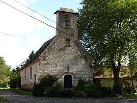 The church of Vacquerie-le-Boucq | |
 Vacquerie-le-Boucq Location within Hauts-de-France region  Vacquerie-le-Boucq | |
| Coordinates: 50°16′N 2°13′E / 50.27°N 2.22°ECoordinates: 50°16′N 2°13′E / 50.27°N 2.22°E | |
| Country | France |
| Region | Hauts-de-France |
| Department | Pas-de-Calais |
| Arrondissement | Arras |
| Canton | Saint-Pol-sur-Ternoise |
| Intercommunality | CC Ternois |
| Government | |
| • Mayor (2008–2014) | Michel Legrand |
| Area1 | 3.3 km2 (1.3 sq mi) |
| Population (2006)2 | 89 |
| • Density | 27/km2 (70/sq mi) |
| Time zone | UTC+1 (CET) |
| • Summer (DST) | UTC+2 (CEST) |
| INSEE/Postal code | 62833 /62270 |
| Elevation |
100–141 m (328–463 ft) (avg. 129 m or 423 ft) |
|
1 French Land Register data, which excludes lakes, ponds, glaciers > 1 km2 (0.386 sq mi or 247 acres) and river estuaries. 2 Population without double counting: residents of multiple communes (e.g., students and military personnel) only counted once. | |
Vacquerie-le-Boucq is a commune in the Pas-de-Calais department in the Hauts-de-France region of France.
Geography
Vacquerie-le-Boucq lies 29 miles (46.7 km) west of Arras, at the junction of the D941 and D115 roads.
Population
| Year | 1962 | 1968 | 1975 | 1982 | 1990 | 1999 | 2006 |
|---|---|---|---|---|---|---|---|
| Population | 120 | 130 | 116 | 109 | 119 | 95 | 89 |
| From the year 1962 on: No double counting—residents of multiple communes (e.g. students and military personnel) are counted only once. | |||||||
Places of interest
- The church of Notre-Dame, dating from the eighteenth century.
See also
References
External links
| Wikimedia Commons has media related to Vacquerie-le-Boucq. |
This article is issued from
Wikipedia.
The text is licensed under Creative Commons - Attribution - Sharealike.
Additional terms may apply for the media files.