Palluel
| Palluel | |
|---|---|
| Commune | |
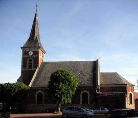 The church of Palluel | |
 Palluel Location within Hauts-de-France region  Palluel | |
| Coordinates: 50°16′05″N 3°05′57″E / 50.2681°N 3.0992°ECoordinates: 50°16′05″N 3°05′57″E / 50.2681°N 3.0992°E | |
| Country | France |
| Region | Hauts-de-France |
| Department | Pas-de-Calais |
| Arrondissement | Arras |
| Canton | Bapaume |
| Intercommunality | CC Osartis Marquion |
| Government | |
| • Mayor (2008–2014) | Jean-François Lemaire |
| Area1 | 2.77 km2 (1.07 sq mi) |
| Population (2006)2 | 572 |
| • Density | 210/km2 (530/sq mi) |
| Time zone | UTC+1 (CET) |
| • Summer (DST) | UTC+2 (CEST) |
| INSEE/Postal code | 62646 /62860 |
| Elevation | 34–60 m (112–197 ft) |
|
1 French Land Register data, which excludes lakes, ponds, glaciers > 1 km2 (0.386 sq mi or 247 acres) and river estuaries. 2 Population without double counting: residents of multiple communes (e.g., students and military personnel) only counted once. | |
Palluel is a commune in the Pas-de-Calais department in the Hauts-de-France region of France.
Geography
Palluel is situated 19 miles (31 km) east of Arras, at the junction of the D21 and D13 roads, in the valley of the river Sensée.
History
The entire village was rebuilt after the ravages of World War I.
The commune was devastated by a tornado of category F5 on June 24, 1967. This tornado was one of the biggest ever recorded in France since at least 1850.
Population
| 1962 | 1968 | 1975 | 1982 | 1990 | 1999 | 2006 |
|---|---|---|---|---|---|---|
| 479 | 508 | 522 | 565 | 525 | 520 | 572 |
| Census count starting from 1962: Population without duplicates | ||||||
Places of interest
- The church, dating from the twentieth century.
- The lakes.
See also
References
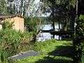 The fishing lakes at Palluel
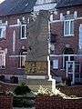 Palluel’s war memorial
External links
| Wikimedia Commons has media related to Palluel. |
- Palluel on the Quid website (in French)
| Authority control |
|---|
This article is issued from
Wikipedia.
The text is licensed under Creative Commons - Attribution - Sharealike.
Additional terms may apply for the media files.