Pressy
| Pressy | ||
|---|---|---|
| Commune | ||
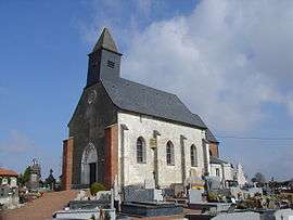 The church of Pressy | ||
| ||
 Pressy Location within Hauts-de-France region  Pressy | ||
| Coordinates: 50°28′32″N 2°23′49″E / 50.4756°N 2.3969°E / 50.4756; 2.3969Coordinates: 50°28′32″N 2°23′49″E / 50.4756°N 2.3969°E / 50.4756; 2.3969 | ||
| Country | France | |
| Region | Hauts-de-France | |
| Department | Pas-de-Calais | |
| Arrondissement | Arras | |
| Canton | Saint-Pol-sur-Ternoise | |
| Intercommunality | CC Ternois | |
| Government | ||
| • Mayor (2008–2014) | Bernard Malle | |
| Area1 | 4.33 km2 (1.67 sq mi) | |
| Population (2006)2 | 278 | |
| • Density | 64/km2 (170/sq mi) | |
| Time zone | UTC+1 (CET) | |
| • Summer (DST) | UTC+2 (CEST) | |
| INSEE/Postal code | 62669 /62550 | |
| Elevation |
75–158 m (246–518 ft) (avg. 107 m or 351 ft) | |
|
1 French Land Register data, which excludes lakes, ponds, glaciers > 1 km2 (0.386 sq mi or 247 acres) and river estuaries. 2 Population without double counting: residents of multiple communes (e.g., students and military personnel) only counted once. | ||

Pressy is a commune in the Pas-de-Calais department in the Hauts-de-France region of France.
Geography
Pressy is a suburb of Pernes, situated 27 miles (43 km) northwest of Arras, on the D77E3 road.
Population
| 1962 | 1968 | 1975 | 1982 | 1990 | 1999 | 2006 |
|---|---|---|---|---|---|---|
| 307 | 328 | 317 | 329 | 313 | 284 | 278 |
| Census count starting from 1962: Population without duplicates | ||||||
Places of interest
- The church of St. Martin, dating from the nineteenth century.
- An eighteenth-century animal trough.
See also
References
External links
| Wikimedia Commons has media related to Pressy (Pas-de-Calais). |
- Pressy on the Quid website (in French)
| Authority control |
|---|
This article is issued from
Wikipedia.
The text is licensed under Creative Commons - Attribution - Sharealike.
Additional terms may apply for the media files.