Waben
| Waben | ||
|---|---|---|
| Commune | ||
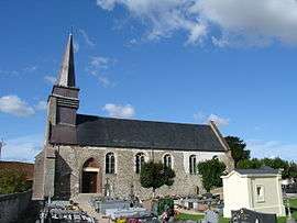 The church of Waben | ||
| ||
 Waben Location within Hauts-de-France region  Waben | ||
| Coordinates: 50°22′48″N 1°39′11″E / 50.38°N 1.6531°ECoordinates: 50°22′48″N 1°39′11″E / 50.38°N 1.6531°E | ||
| Country | France | |
| Region | Hauts-de-France | |
| Department | Pas-de-Calais | |
| Arrondissement | Montreuil | |
| Canton | Berck | |
| Intercommunality | Communauté d'agglomération des Deux Baies en Montreuillois | |
| Government | ||
| • Mayor (2014-2020) | Jean-Claude Gauduin | |
| Area1 | 8.99 km2 (3.47 sq mi) | |
| Population (2014)2 | 425 | |
| • Density | 47/km2 (120/sq mi) | |
| Time zone | UTC+1 (CET) | |
| • Summer (DST) | UTC+2 (CEST) | |
| INSEE/Postal code | 62866 /62180 | |
| Elevation |
3–51 m (9.8–167.3 ft) (avg. 9 m or 30 ft) | |
|
1 French Land Register data, which excludes lakes, ponds, glaciers > 1 km2 (0.386 sq mi or 247 acres) and river estuaries. 2 Population without double counting: residents of multiple communes (e.g., students and military personnel) only counted once. | ||

Waben is a commune in the Pas-de-Calais department in the Hauts-de-France region of France.
Geography
Waben is located 8 miles (13 km) southwest of Montreuil-sur-Mer, at the D143 and D940 road junction, about a kilometre from the sea at the bay of the Authie.
Population
| Year | 1962 | 1968 | 1975 | 1982 | 1990 | 1999 | 2006 | 2014 |
|---|---|---|---|---|---|---|---|---|
| Population | 234 | 234 | 235 | 266 | 294 | 327 | 382 | 425 |
| From the year 1962 on: No double counting—residents of multiple communes (e.g. students and military personnel) are counted only once. | ||||||||
Places of interest
- The church of the Nativité-de-Notre-Dame.
See also
References
External links
| Wikimedia Commons has media related to Waben. |
- Waben on the Quid website (in French)
This article is issued from
Wikipedia.
The text is licensed under Creative Commons - Attribution - Sharealike.
Additional terms may apply for the media files.