Belle-et-Houllefort
| Belle-et-Houllefort | ||
|---|---|---|
| Commune | ||
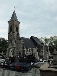 The church of Belle-et-Houllefort | ||
| ||
 Belle-et-Houllefort Location within Hauts-de-France region  Belle-et-Houllefort | ||
| Coordinates: 50°44′39″N 1°45′34″E / 50.7442°N 1.7594°ECoordinates: 50°44′39″N 1°45′34″E / 50.7442°N 1.7594°E | ||
| Country | France | |
| Region | Hauts-de-France | |
| Department | Pas-de-Calais | |
| Arrondissement | Boulogne-sur-Mer | |
| Canton | Desvres | |
| Intercommunality | CC Desvres-Samer | |
| Government | ||
| • Mayor (2008–2014) | Jules Humières | |
| Area1 | 9.14 km2 (3.53 sq mi) | |
| Population (2009)2 | 537 | |
| • Density | 59/km2 (150/sq mi) | |
| Time zone | UTC+1 (CET) | |
| • Summer (DST) | UTC+2 (CEST) | |
| INSEE/Postal code | 62105 /62142 | |
| Elevation |
26–84 m (85–276 ft) (avg. 40 m or 130 ft) | |
|
1 French Land Register data, which excludes lakes, ponds, glaciers > 1 km2 (0.386 sq mi or 247 acres) and river estuaries. 2 Population without double counting: residents of multiple communes (e.g., students and military personnel) only counted once. | ||

Belle-et-Houllefort is a commune in the Pas-de-Calais department in the Hauts-de-France region in northern France.
Geography
A farming and quarrying commune, some 8 miles (13 km) northeast of Boulogne, at the junction of the N42, D233 and the D238 roads and by the banks of the river Wimereux.
Population
| Historical population | ||
|---|---|---|
| Year | Pop. | ±% |
| 1962 | 256 | — |
| 1968 | 267 | +4.3% |
| 1975 | 278 | +4.1% |
| 1982 | 340 | +22.3% |
| 1990 | 405 | +19.1% |
| 1999 | 533 | +31.6% |
| 2009 | 537 | +0.8% |
Sights
- The ruins of a fortified house.
- The church at Belle, dating from the twelfth century.
- The church at Houllefort, dating from the seventeenth century.
- The sixteenth century manorhouse du Major.
- The Hôtel-de-ville, built in 1862.
See also
References
External links
| Wikimedia Commons has media related to Belle-et-Houllefort. |
- Belle-et-Houllefort on the Quid website (in French)
This article is issued from
Wikipedia.
The text is licensed under Creative Commons - Attribution - Sharealike.
Additional terms may apply for the media files.