Écuires
| Écuires | ||
|---|---|---|
| Commune | ||
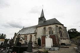 The church of Écuires | ||
| ||
 Écuires Location within Hauts-de-France region  Écuires | ||
| Coordinates: 50°26′50″N 1°45′43″E / 50.4472°N 1.7619°E / 50.4472; 1.7619Coordinates: 50°26′50″N 1°45′43″E / 50.4472°N 1.7619°E / 50.4472; 1.7619 | ||
| Country | France | |
| Region | Hauts-de-France | |
| Department | Pas-de-Calais | |
| Arrondissement | Montreuil | |
| Canton | Berck | |
| Intercommunality | CA Deux Baies en Montreuillois | |
| Government | ||
| • Mayor (2001–2008) | Alain Noyelles | |
| Area1 | 9.15 km2 (3.53 sq mi) | |
| Population (1999)2 | 830 | |
| • Density | 91/km2 (230/sq mi) | |
| Time zone | UTC+1 (CET) | |
| • Summer (DST) | UTC+2 (CEST) | |
| INSEE/Postal code | 62289 /62170 | |
| Elevation |
5–65 m (16–213 ft) (avg. 15 m or 49 ft) | |
|
1 French Land Register data, which excludes lakes, ponds, glaciers > 1 km2 (0.386 sq mi or 247 acres) and river estuaries. 2 Population without double counting: residents of multiple communes (e.g., students and military personnel) only counted once. | ||

Écuires is a commune in the Pas-de-Calais department in the Hauts-de-France region of France.
Geography
A village situated just outside Montreuil-sur-Mer on the N1 road.
Places of interest
- The fifteenth-century church of St. Vaast
- The sixteenth-century Château du Quiévremont
Population
| Year | 1962 | 1968 | 1975 | 1982 | 1990 | 1999 |
|---|---|---|---|---|---|---|
| Population | 579 | 586 | 670 | 795 | 878 | 830 |
| From the year 1962 on: No double counting—residents of multiple communes (e.g. students and military personnel) are counted only once. | ||||||
See also
References
External links
| Wikimedia Commons has media related to Écuires. |
- Écuires on the Quid website (in French)
This article is issued from
Wikipedia.
The text is licensed under Creative Commons - Attribution - Sharealike.
Additional terms may apply for the media files.