Gouy-Servins
| Gouy-Servins | ||
|---|---|---|
| Commune | ||
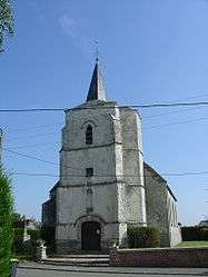 The church of Gouy-Servins | ||
| ||
 Gouy-Servins Location within Hauts-de-France region  Gouy-Servins | ||
| Coordinates: 50°24′14″N 2°39′02″E / 50.4039°N 2.6506°ECoordinates: 50°24′14″N 2°39′02″E / 50.4039°N 2.6506°E | ||
| Country | France | |
| Region | Hauts-de-France | |
| Department | Pas-de-Calais | |
| Arrondissement | Lens | |
| Canton | Bully-les-Mines | |
| Intercommunality | CA Lens-Liévin | |
| Government | ||
| • Mayor (2008–2014) | Alain Lherbier | |
| Area1 | 3.32 km2 (1.28 sq mi) | |
| Population (2004)2 | 299 | |
| • Density | 90/km2 (230/sq mi) | |
| Time zone | UTC+1 (CET) | |
| • Summer (DST) | UTC+2 (CEST) | |
| INSEE/Postal code | 62380 /62530 | |
| Elevation |
124–171 m (407–561 ft) (avg. 160 m or 520 ft) | |
|
1 French Land Register data, which excludes lakes, ponds, glaciers > 1 km2 (0.386 sq mi or 247 acres) and river estuaries. 2 Population without double counting: residents of multiple communes (e.g., students and military personnel) only counted once. | ||

Gouy-Servins is a commune in the Pas-de-Calais department in the Hauts-de-France region of France.
Geography
A small farming village situated some 10 miles (16.1 km) west of Lens, at the junction of the D57 and the D75.
Population
| Year | 1962 | 1968 | 1975 | 1982 | 1990 | 1999 | 2004 |
|---|---|---|---|---|---|---|---|
| Population | 212 | 239 | 217 | 242 | 288 | 297 | 299 |
| From the year 1962 on: No double counting—residents of multiple communes (e.g. students and military personnel) are counted only once. | |||||||
Places of interest
- The church of St.Roch, dating from the sixteenth century.
- The war memorial and the CWGC graves.
See also
References
External links
| Wikimedia Commons has media related to Gouy-Servins. |
- The CWGC graves in the communal cemetery
- Website of the Communaupole de Lens-Liévin (in French)
- Gouy-Servins on the Quid website (in French)
| Authority control |
|---|
This article is issued from
Wikipedia.
The text is licensed under Creative Commons - Attribution - Sharealike.
Additional terms may apply for the media files.