Humières
| Humières | ||
|---|---|---|
| Commune | ||
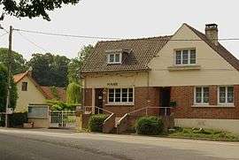 The town hall of Humieres | ||
| ||
 Humières Location within Hauts-de-France region  Humières | ||
| Coordinates: 50°23′20″N 2°12′29″E / 50.3889°N 2.2081°ECoordinates: 50°23′20″N 2°12′29″E / 50.3889°N 2.2081°E | ||
| Country | France | |
| Region | Hauts-de-France | |
| Department | Pas-de-Calais | |
| Arrondissement | Arras | |
| Canton | Saint-Pol-sur-Ternoise | |
| Intercommunality | CC Ternois | |
| Government | ||
| • Mayor (2008–2014) | René Larousse | |
| Area1 | 6.81 km2 (2.63 sq mi) | |
| Population (2006)2 | 242 | |
| • Density | 36/km2 (92/sq mi) | |
| Time zone | UTC+1 (CET) | |
| • Summer (DST) | UTC+2 (CEST) | |
| INSEE/Postal code | 62468 /62130 | |
| Elevation |
83–133 m (272–436 ft) (avg. 128 m or 420 ft) | |
|
1 French Land Register data, which excludes lakes, ponds, glaciers > 1 km2 (0.386 sq mi or 247 acres) and river estuaries. 2 Population without double counting: residents of multiple communes (e.g., students and military personnel) only counted once. | ||

Humières is a commune in the Pas-de-Calais department in the Hauts-de-France region of France.
Geography
A farming village situated 28 miles (45 km) west of Arras, at the junction of the N39, D105 and the D98 roads.
Population
| Year | 1962 | 1968 | 1975 | 1982 | 1990 | 1999 | 2006 |
|---|---|---|---|---|---|---|---|
| Population | 225 | 248 | 224 | 243 | 219 | 232 | 242 |
| From the year 1962 on: No double counting—residents of multiple communes (e.g. students and military personnel) are counted only once. | |||||||
Places of interest
- The church of St. Martin, dating from the seventeenth century.
- The eighteenth-century chateau.
See also
References
External links
| Wikimedia Commons has media related to Humières. |
- Humières on the Quid website (in French)
This article is issued from
Wikipedia.
The text is licensed under Creative Commons - Attribution - Sharealike.
Additional terms may apply for the media files.