Campagne-lès-Hesdin
| Campagne-lès-Hesdin | ||
|---|---|---|
| Commune | ||
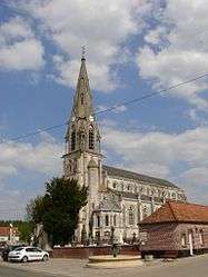 The church of Campagne-lès-Hesdin | ||
| ||
 Campagne-lès-Hesdin Location within Hauts-de-France region  Campagne-lès-Hesdin | ||
| Coordinates: 50°23′54″N 1°52′39″E / 50.3983°N 1.8775°ECoordinates: 50°23′54″N 1°52′39″E / 50.3983°N 1.8775°E | ||
| Country | France | |
| Region | Hauts-de-France | |
| Department | Pas-de-Calais | |
| Arrondissement | Montreuil | |
| Canton | Auxi-le-Château | |
| Intercommunality | CC Sept Vallées | |
| Government | ||
| • Mayor (2001–2008) | Philippe Dewitte | |
| Area1 | 15.64 km2 (6.04 sq mi) | |
| Population (2010)2 | 1,765 | |
| • Density | 110/km2 (290/sq mi) | |
| Time zone | UTC+1 (CET) | |
| • Summer (DST) | UTC+2 (CEST) | |
| INSEE/Postal code | 62204 /62870 | |
| Elevation |
29–94 m (95–308 ft) (avg. 90 m or 300 ft) | |
|
1 French Land Register data, which excludes lakes, ponds, glaciers > 1 km2 (0.386 sq mi or 247 acres) and river estuaries. 2 Population without double counting: residents of multiple communes (e.g., students and military personnel) only counted once. | ||

Campagne-lès-Hesdin is a commune in the Pas-de-Calais department in northern France.
Geography
On the D138, between the towns of Hesdin and Montreuil and the valleys of the rivers Canche and Authie, the town is surrounded by sheep- and dairy-farming.
International relations
Campagne-lès-Hesdin is twinned with:
Population
| Year | 1962 | 1968 | 1975 | 1982 | 1990 | 1999 |
|---|---|---|---|---|---|---|
| Population | 1152 | 1334 | 1448 | 1474 | 1604 | 1696 |
| From the year 1962 on: No double counting—residents of multiple communes (e.g. students and military personnel) are counted only once. | ||||||
See also
References
- ↑ "British towns twinned with French towns". Archant Community Media Ltd. Archived from the original on 2013-07-05. Retrieved 2013-07-11.
External links
| Wikimedia Commons has media related to Campagne-lès-Hesdin. |
- Campagne-lès-Hesdin on the Quid website (in French)
This article is issued from
Wikipedia.
The text is licensed under Creative Commons - Attribution - Sharealike.
Additional terms may apply for the media files.