Ostreville
| Ostreville | ||
|---|---|---|
| Commune | ||
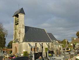 The church of Ostreville | ||
| ||
 Ostreville Location within Hauts-de-France region  Ostreville | ||
| Coordinates: 50°23′51″N 2°23′41″E / 50.3975°N 2.3947°ECoordinates: 50°23′51″N 2°23′41″E / 50.3975°N 2.3947°E | ||
| Country | France | |
| Region | Hauts-de-France | |
| Department | Pas-de-Calais | |
| Arrondissement | Arras | |
| Canton | Saint-Pol-sur-Ternoise | |
| Intercommunality | CC Ternois | |
| Government | ||
| • Mayor (2008–2014) | Anthony Pruvost | |
| Area1 | 3.88 km2 (1.50 sq mi) | |
| Population (2006)2 | 285 | |
| • Density | 73/km2 (190/sq mi) | |
| Time zone | UTC+1 (CET) | |
| • Summer (DST) | UTC+2 (CEST) | |
| INSEE/Postal code | 62641 /62130 | |
| Elevation |
115–161 m (377–528 ft) (avg. 150 m or 490 ft) | |
|
1 French Land Register data, which excludes lakes, ponds, glaciers > 1 km2 (0.386 sq mi or 247 acres) and river estuaries. 2 Population without double counting: residents of multiple communes (e.g., students and military personnel) only counted once. | ||

Ostreville is a commune in the Pas-de-Calais department in the Hauts-de-France region of France.
Geography
Ostreville is situated 22 miles (35 km) northwest of Arras, at the junction of the D81 and D86 roads.
Heraldry
_Nord-France.svg.png) |
The arms of Ostreville are blazoned : Azure, an inescutcheon argent. (Gouzeaucourt, Saint-Jean-de-Vals, Ramburelles, Saint-Menge, Colombey-les-Belles and Ostreville use the same arms.) |
Population
| 1962 | 1968 | 1975 | 1982 | 1990 | 1999 | 2006 |
|---|---|---|---|---|---|---|
| 217 | 244 | 241 | 249 | 265 | 276 | 285 |
| Census count starting from 1962: Population without duplicates | ||||||
Places of interest
- The church of St.Pierre, dating from the seventeenth century.
See also
References
External links
| Wikimedia Commons has media related to Ostreville. |
- Ostreville on the Quid website (in French)
This article is issued from
Wikipedia.
The text is licensed under Creative Commons - Attribution - Sharealike.
Additional terms may apply for the media files.