Méricourt, Pas-de-Calais
| Méricourt | ||
|---|---|---|
| Commune | ||
_-_1.JPG) The town hall of Méricourt | ||
| ||
 Méricourt Location within Hauts-de-France region  Méricourt | ||
| Coordinates: 50°24′11″N 2°52′00″E / 50.4031°N 2.8667°ECoordinates: 50°24′11″N 2°52′00″E / 50.4031°N 2.8667°E | ||
| Country | France | |
| Region | Hauts-de-France | |
| Department | Pas-de-Calais | |
| Arrondissement | Lens | |
| Canton | Avion | |
| Intercommunality | CA Lens-Liévin | |
| Government | ||
| • Mayor (2008–2014) | Bernard Baude | |
| Area1 | 7.53 km2 (2.91 sq mi) | |
| Population (2006)2 | 11,938 | |
| • Density | 1,600/km2 (4,100/sq mi) | |
| Time zone | UTC+1 (CET) | |
| • Summer (DST) | UTC+2 (CEST) | |
| INSEE/Postal code | 62570 /62680 | |
| Elevation |
31–63 m (102–207 ft) (avg. 55 m or 180 ft) | |
|
1 French Land Register data, which excludes lakes, ponds, glaciers > 1 km2 (0.386 sq mi or 247 acres) and river estuaries. 2 Population without double counting: residents of multiple communes (e.g., students and military personnel) only counted once. | ||

Méricourt (French pronunciation: [meʁikuʁ]) is a commune in the Pas-de-Calais department in the Hauts-de-France region of France.
Geography
Méricourt is a former coal mining town, nowadays a farming and light industrial town, 3 miles (4.8 km) southeast of Lens, at the junction of the D33, D40 and the D262 roads. The commune is part of the canton of Avion.
History
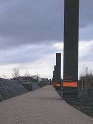
The history of the region remains marked by the Courrières mine disaster, which left 1,099 dead on 10 March 1906. The communes affected were Méricourt, Billy-Montigny, Noyelles-sous-Lens and Sallaumines.
It was at Méricourt that the memorial to the mining disaster was erected. Since 2006, the memorial has also included an overground pathway retracing the route underground of the survivors who managed to get out of the galleries about three weeks after the collapse and resulting firedamp and dust.
Population
| 1962 | 1968 | 1975 | 1982 | 1990 | 1999 | 2006 |
|---|---|---|---|---|---|---|
| 13,200 | 13,416 | 13,806 | 13,273 | 12,330 | 11,723 | 11,938 |
| Census count starting from 1962: Population without duplicates | ||||||
Places of interest
- The church of St.Martin, rebuilt along with most of the town, after the First World War.
- The church of St.Barbe, dating from the nineteenth century.
- Vestiges of an old chateau.
- The memorials.

See also
References
External links
| Wikimedia Commons has media related to Méricourt, Pas-de-Calais. |
- Official town website (in French)
- Méricourt on the Quid website (in French)