Bihucourt
| Bihucourt | ||
|---|---|---|
| Commune | ||
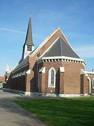 The church of Bihucourt | ||
| ||
 Bihucourt Location within Hauts-de-France region  Bihucourt | ||
| Coordinates: 50°07′36″N 2°48′02″E / 50.1267°N 2.8006°E / 50.1267; 2.8006Coordinates: 50°07′36″N 2°48′02″E / 50.1267°N 2.8006°E / 50.1267; 2.8006 | ||
| Country | France | |
| Region | Hauts-de-France | |
| Department | Pas-de-Calais | |
| Arrondissement | Arras | |
| Canton | Bapaume | |
| Intercommunality | CC Sud-Artois | |
| Government | ||
| • Mayor (2008–2014) | Maryse Mouronval | |
| Area1 | 4.67 km2 (1.80 sq mi) | |
| Population (2009)2 | 366 | |
| • Density | 78/km2 (200/sq mi) | |
| Time zone | UTC+1 (CET) | |
| • Summer (DST) | UTC+2 (CEST) | |
| INSEE/Postal code | 62131 /62121 | |
| Elevation |
102–131 m (335–430 ft) (avg. 116 m or 381 ft) | |
|
1 French Land Register data, which excludes lakes, ponds, glaciers > 1 km2 (0.386 sq mi or 247 acres) and river estuaries. 2 Population without double counting: residents of multiple communes (e.g., students and military personnel) only counted once. | ||

Bihucourt is a commune in the Pas-de-Calais department in the Hauts-de-France region in northern France.
Geography
A farming village located 11 miles (18 km) south of Arras at the junction of the D31 and the D7.
Population
| Historical population | ||
|---|---|---|
| Year | Pop. | ±% |
| 1962 | 328 | — |
| 1968 | 328 | +0.0% |
| 1975 | 262 | −20.1% |
| 1982 | 289 | +10.3% |
| 1990 | 307 | +6.2% |
| 1999 | 305 | −0.7% |
| 2009 | 366 | +20.0% |
Sights
- The church of St. Vaast, which, like most of the village, was rebuilt after the ravages of World War I.
- The war memorial.
See also
References
External links
| Wikimedia Commons has media related to Bihucourt. |
- Bihucourt on the Quid website (in French)
This article is issued from
Wikipedia.
The text is licensed under Creative Commons - Attribution - Sharealike.
Additional terms may apply for the media files.