Dainville
| Dainville | ||
|---|---|---|
| Commune | ||
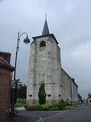 The church of Dainville | ||
| ||
 Dainville Location within Hauts-de-France region  Dainville | ||
| Coordinates: 50°16′58″N 2°43′41″E / 50.2828°N 2.7281°ECoordinates: 50°16′58″N 2°43′41″E / 50.2828°N 2.7281°E | ||
| Country | France | |
| Region | Hauts-de-France | |
| Department | Pas-de-Calais | |
| Arrondissement | Arras | |
| Canton | Arras-1 | |
| Intercommunality | Communauté urbaine d'Arras | |
| Government | ||
| • Mayor (2008–2014) | Françoise Rossignol | |
| Area1 | 11.22 km2 (4.33 sq mi) | |
| Population (1999)2 | 5,392 | |
| • Density | 480/km2 (1,200/sq mi) | |
| Time zone | UTC+1 (CET) | |
| • Summer (DST) | UTC+2 (CEST) | |
| INSEE/Postal code | 62263 /62000 | |
| Elevation |
64–107 m (210–351 ft) (avg. 80 m or 260 ft) | |
|
1 French Land Register data, which excludes lakes, ponds, glaciers > 1 km2 (0.386 sq mi or 247 acres) and river estuaries. 2 Population without double counting: residents of multiple communes (e.g., students and military personnel) only counted once. | ||

Dainville is a commune in the Pas-de-Calais department in the Hauts-de-France region of France.
Geography
A farming and light industrial suburb 2 miles (3.2 km) west of Arras at the junction of the N25 with the D60 and D59 roads.
Population
| Year | 1962 | 1968 | 1975 | 1982 | 1990 | 1999 |
|---|---|---|---|---|---|---|
| Population | 2188 | 2971 | 4839 | 5758 | 5693 | 5392 |
| From the year 1962 on: No double counting—residents of multiple communes (e.g. students and military personnel) are counted only once. | ||||||
Places of interest
- The church of St.Martin, dating from the thirteenth century
Twin towns
Dainville is twinned with the following town:
See also
References
External links
| Wikimedia Commons has media related to Dainville. |
- The CWGC cemetery at Dainville
- The communal cemetery
- Official website of Dainville (in French)
- Official website of the communauté urbaine d'Arras (in French)
- Dainville on the Quid website (in French)
This article is issued from
Wikipedia.
The text is licensed under Creative Commons - Attribution - Sharealike.
Additional terms may apply for the media files.