Nort-Leulinghem
| Nort-Leulinghem | ||
|---|---|---|
| Commune | ||
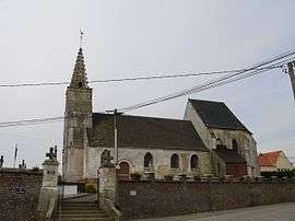 The church of Nort-Leulinghem | ||
| ||
 Nort-Leulinghem Location within Hauts-de-France region  Nort-Leulinghem | ||
| Coordinates: 50°48′02″N 2°05′37″E / 50.8006°N 2.0936°ECoordinates: 50°48′02″N 2°05′37″E / 50.8006°N 2.0936°E | ||
| Country | France | |
| Region | Hauts-de-France | |
| Department | Pas-de-Calais | |
| Arrondissement | Saint-Omer | |
| Canton | Saint-Omer | |
| Intercommunality | Pays de Saint-Omer | |
| Government | ||
| • Mayor | Gérard Lecocq | |
| Area1 | 3.45 km2 (1.33 sq mi) | |
| Population (2006)2 | 201 | |
| • Density | 58/km2 (150/sq mi) | |
| Time zone | UTC+1 (CET) | |
| • Summer (DST) | UTC+2 (CEST) | |
| INSEE/Postal code | 62622 /62890 | |
| Elevation |
41–116 m (135–381 ft) (avg. 50 m or 160 ft) | |
|
1 French Land Register data, which excludes lakes, ponds, glaciers > 1 km2 (0.386 sq mi or 247 acres) and river estuaries. 2 Population without double counting: residents of multiple communes (e.g., students and military personnel) only counted once. | ||

Nort-Leulinghem is a commune in the Pas-de-Calais department in the Hauts-de-France region of France.
Geography
Nort-Leulinghem is locates about 9 miles (14 km) northwest of Saint-Omer, at the junction of the D191 and the D221 roads, half a mile from the A26 autoroute.
Population
| 1962 | 1968 | 1975 | 1982 | 1990 | 1999 | 2006 |
|---|---|---|---|---|---|---|
| 122 | 122 | 109 | 156 | 171 | 177 | 201 |
| Census count starting from 1962: Population without duplicates | ||||||
Places of interest
- The church of St. André, dating from the sixteenth century.
See also
References
External links
| Wikimedia Commons has media related to Nort-Leulinghem. |
- Official Tourist office website (in French)
- Nort-Leulinghem on the Quid website (in French)
| Authority control |
|---|
This article is issued from
Wikipedia.
The text is licensed under Creative Commons - Attribution - Sharealike.
Additional terms may apply for the media files.