Humbert, Pas-de-Calais
| Humbert | ||
|---|---|---|
| Commune | ||
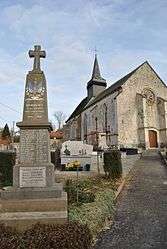 The monument to the dead and church of Humbert | ||
| ||
 Humbert Location within Hauts-de-France region  Humbert | ||
| Coordinates: 50°30′19″N 1°54′28″E / 50.5053°N 1.9078°ECoordinates: 50°30′19″N 1°54′28″E / 50.5053°N 1.9078°E | ||
| Country | France | |
| Region | Hauts-de-France | |
| Department | Pas-de-Calais | |
| Arrondissement | Montreuil | |
| Canton | Lumbres | |
| Intercommunality | CC Haut Pays du Montreuillois | |
| Government | ||
| • Mayor (2001–2008) | Jean-Marie Leclercq | |
| Area1 | 7.85 km2 (3.03 sq mi) | |
| Population (2006)2 | 252 | |
| • Density | 32/km2 (83/sq mi) | |
| Time zone | UTC+1 (CET) | |
| • Summer (DST) | UTC+2 (CEST) | |
| INSEE/Postal code | 62466 /62650 | |
| Elevation |
47–147 m (154–482 ft) (avg. 57 m or 187 ft) | |
|
1 French Land Register data, which excludes lakes, ponds, glaciers > 1 km2 (0.386 sq mi or 247 acres) and river estuaries. 2 Population without double counting: residents of multiple communes (e.g., students and military personnel) only counted once. | ||

Humbert is a commune in the Pas-de-Calais department in the Hauts-de-France region of France.
Geography
Situated some 8 miles (12 km) northeast of Montreuil-sur-Mer on the D129 road.
Population
| Year | 1962 | 1968 | 1975 | 1982 | 1990 | 1999 | 2006 |
|---|---|---|---|---|---|---|---|
| Population | 228 | 238 | 225 | 196 | 248 | 254 | 252 |
| From the year 1962 on: No double counting—residents of multiple communes (e.g. students and military personnel) are counted only once. | |||||||
Places of interest
- The church of St.Peter, dating from the sixteenth century.
See also
References
External links
| Wikimedia Commons has media related to Humbert (Pas-de-Calais). |
- Humbert on the Quid website (in French)
| Authority control |
|---|
This article is issued from
Wikipedia.
The text is licensed under Creative Commons - Attribution - Sharealike.
Additional terms may apply for the media files.