Arrondissement of Lens
| Lens | |
|---|---|
| Arrondissement | |
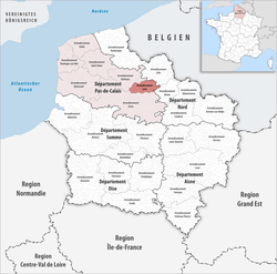 Location of Lens in Hauts-de-France | |
| Country | France |
| Region | Hauts-de-France |
| Department | Pas-de-Calais |
| Communes | 50 |
| Subprefecture | Lens |
| Area¹ | |
| • Total | 352.1 km2 (135.9 sq mi) |
| Population (2013) | |
| • Total | 358,694 |
| • Density | 1,000/km2 (2,600/sq mi) |
| ¹ French Land Register data, which exclude lakes, ponds, and glaciers larger than 1 km² as well as the estuaries of rivers. | |
The arrondissement of Lens is an arrondissement of northern France in the Pas-de-Calais department in the Hauts-de-France region. In 2007 it absorbed the two cantons of Avion and Rouvroy from the arrondissement of Arras.[1] Since the January 2017 reorganization of the arrondissements of Pas-de-Calais, it has 50 communes.[2]
Composition
Cantons
The cantons of the arrondissement of Lens are:
Communes
The communes of the arrondissement of Lens, and their INSEE codes, are:
- Ablain-Saint-Nazaire (62001)
- Acheville (62003)
- Aix-Noulette (62019)
- Angres (62032)
- Annay (62033)
- Avion (62065)
- Bénifontaine (62107)
- Billy-Montigny (62133)
- Bois-Bernard (62148)
- Bouvigny-Boyeffles (62170)
- Bully-les-Mines (62186)
- Carency (62213)
- Carvin (62215)
- Courcelles-lès-Lens (62249)
- Courrières (62250)
- Dourges (62274)
- Drocourt (62277)
- Éleu-dit-Leauwette (62291)
- Estevelles (62311)
- Évin-Malmaison (62321)
- Fouquières-lès-Lens (62351)
- Givenchy-en-Gohelle (62371)
- Gouy-Servins (62380)
- Grenay (62386)
- Harnes (62413)
- Hénin-Beaumont (62427)
- Hulluch (62464)
- Leforest (62497)
- Lens (62498)
- Libercourt (62907)
- Liévin (62510)
- Loison-sous-Lens (62523)
- Loos-en-Gohelle (62528)
- Mazingarbe (62563)
- Méricourt (62570)
- Meurchin (62573)
- Montigny-en-Gohelle (62587)
- Noyelles-Godault (62624)
- Noyelles-sous-Lens (62628)
- Oignies (62637)
- Pont-à-Vendin (62666)
- Rouvroy (62724)
- Sains-en-Gohelle (62737)
- Sallaumines (62771)
- Servins (62793)
- Souchez (62801)
- Vendin-le-Vieil (62842)
- Villers-au-Bois (62854)
- Vimy (62861)
- Wingles (62895)
References
- ↑ INSEE, Modifications territoriales
- ↑ "Arrêté préfectoral, 20 December 2016" (PDF). Retrieved 2017-07-27.
External links
This article is issued from
Wikipedia.
The text is licensed under Creative Commons - Attribution - Sharealike.
Additional terms may apply for the media files.