Grévillers
| Grévillers | ||
|---|---|---|
| Commune | ||
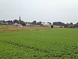 A general view of Grévillers and the British Cemetery | ||
| ||
 Grévillers Location within Hauts-de-France region  Grévillers | ||
| Coordinates: 50°06′23″N 2°48′43″E / 50.1064°N 2.8119°ECoordinates: 50°06′23″N 2°48′43″E / 50.1064°N 2.8119°E | ||
| Country | France | |
| Region | Hauts-de-France | |
| Department | Pas-de-Calais | |
| Arrondissement | Arras | |
| Canton | Bapaume | |
| Intercommunality | CC Sud-Artois | |
| Government | ||
| • Mayor (2008–2014) | Paul Lequette | |
| Area1 | 6.35 km2 (2.45 sq mi) | |
| Population (1999)2 | 331 | |
| • Density | 52/km2 (140/sq mi) | |
| Time zone | UTC+1 (CET) | |
| • Summer (DST) | UTC+2 (CEST) | |
| INSEE/Postal code | 62387 /62450 | |
| Elevation |
108–136 m (354–446 ft) (avg. 119 m or 390 ft) | |
|
1 French Land Register data, which excludes lakes, ponds, glaciers > 1 km2 (0.386 sq mi or 247 acres) and river estuaries. 2 Population without double counting: residents of multiple communes (e.g., students and military personnel) only counted once. | ||

Grévillers is a commune in the Pas-de-Calais department in the Hauts-de-France region of France.
Geography
A farming village situated 15 miles (24 km) south of Arras, at the junction of the D10 and three small roads.
Population
| Year | 1962 | 1968 | 1975 | 1982 | 1990 | 1999 |
|---|---|---|---|---|---|---|
| Population | 363 | 362 | 331 | 330 | 326 | 331 |
| From the year 1962 on: No double counting—residents of multiple communes (e.g. students and military personnel) are counted only once. | ||||||
Places of interest
- The church of Notre-Dame, dating from the seventeenth century.
- The Commonwealth War Graves Commission cemetery.
- Memorial to General Aubert Frere, born here in 1881.
See also
References
External links
| Wikimedia Commons has media related to Grévillers. |
- The CWGC cemetery at Grévillers
- South Africans buried in Grevillers British Cemetery
- The memorial to Gen. Frere (in French)
- Grévillers on the Quid website (in French)
| Authority control |
|---|
This article is issued from
Wikipedia.
The text is licensed under Creative Commons - Attribution - Sharealike.
Additional terms may apply for the media files.