Beugnâtre
| Beugnâtre | ||
|---|---|---|
| Commune | ||
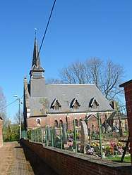 The church of Beugnâtre | ||
| ||
 Beugnâtre Location within Hauts-de-France region  Beugnâtre | ||
| Coordinates: 50°07′49″N 2°52′35″E / 50.1303°N 2.8764°E / 50.1303; 2.8764Coordinates: 50°07′49″N 2°52′35″E / 50.1303°N 2.8764°E / 50.1303; 2.8764 | ||
| Country | France | |
| Region | Hauts-de-France | |
| Department | Pas-de-Calais | |
| Arrondissement | Arras | |
| Canton | Bapaume | |
| Intercommunality | CC Sud-Artois | |
| Government | ||
| • Mayor (2008–2014) | Jacques Weexsteen | |
| Area1 | 3.97 km2 (1.53 sq mi) | |
| Population (2009)2 | 135 | |
| • Density | 34/km2 (88/sq mi) | |
| Time zone | UTC+1 (CET) | |
| • Summer (DST) | UTC+2 (CEST) | |
| INSEE/Postal code | 62121 /62450 | |
| Elevation |
98–117 m (322–384 ft) (avg. 119 m or 390 ft) | |
|
1 French Land Register data, which excludes lakes, ponds, glaciers > 1 km2 (0.386 sq mi or 247 acres) and river estuaries. 2 Population without double counting: residents of multiple communes (e.g., students and military personnel) only counted once. | ||

Beugnâtre is a commune in the Pas-de-Calais department in the Hauts-de-France region in northern France.
Geography
A small farming village located 15 miles (24 km) southeast of Arras at the junction of the D956 and D10E roads. The A1 autoroute passes by just yards from the commune.
Population
| Historical population | ||
|---|---|---|
| Year | Pop. | ±% |
| 1962 | 99 | — |
| 1968 | 109 | +10.1% |
| 1975 | 103 | −5.5% |
| 1982 | 97 | −5.8% |
| 1990 | 101 | +4.1% |
| 1999 | 123 | +21.8% |
| 2009 | 135 | +9.8% |
Sights
- The church of St. Leger, rebuilt, like most of the village, after the ravages of World War I.
See also
References
External links
| Wikimedia Commons has media related to Beugnâtre. |
- Beugnâtre on the Quid website (in French)
This article is issued from
Wikipedia.
The text is licensed under Creative Commons - Attribution - Sharealike.
Additional terms may apply for the media files.