Terres-de-Caux
| Terres-de-Caux | |
|---|---|
| Commune | |
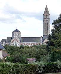 The church in Fauville-en-Caux | |
 Terres-de-Caux Location within Normandy region  Terres-de-Caux | |
| Coordinates: 49°39′14″N 0°35′31″E / 49.654°N 0.592°ECoordinates: 49°39′14″N 0°35′31″E / 49.654°N 0.592°E | |
| Country | France |
| Region | Normandy |
| Department | Seine-Maritime |
| Arrondissement | Le Havre |
| Canton | Saint-Valery-en-Caux |
| Intercommunality | CC Cœur Caux |
| Government | |
| • Mayor (2017-2020) | Jean-Marc Vasse |
| Area1 | 38.01 km2 (14.68 sq mi) |
| Population (2014)2 | 4,025 |
| • Density | 110/km2 (270/sq mi) |
| Time zone | UTC+1 (CET) |
| • Summer (DST) | UTC+2 (CEST) |
| INSEE/Postal code | 76258 /76640 |
|
1 French Land Register data, which excludes lakes, ponds, glaciers > 1 km2 (0.386 sq mi or 247 acres) and river estuaries. 2 Population without double counting: residents of multiple communes (e.g., students and military personnel) only counted once. | |
Terres-de-Caux is a commune in the department of Seine-Maritime, northern France. The municipality was established on 1 January 2017 by merger of the former communes of Fauville-en-Caux (the seat), Auzouville-Auberbosc, Bennetot, Bermonville, Ricarville, Sainte-Marguerite-sur-Fauville and Saint-Pierre-Lavis.[1]
See also
References
| Wikimedia Commons has media related to Terres-de-Caux. |
- ↑ Arrêté préfectoral 12 September 2016 (in French)
This article is issued from
Wikipedia.
The text is licensed under Creative Commons - Attribution - Sharealike.
Additional terms may apply for the media files.