Nointot
| Nointot | |
|---|---|
| Commune | |
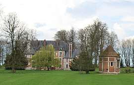 The chateau of Baclair in Nointot | |
 Nointot Location within Normandy region  Nointot | |
| Coordinates: 49°35′56″N 0°28′41″E / 49.5989°N 0.4781°ECoordinates: 49°35′56″N 0°28′41″E / 49.5989°N 0.4781°E | |
| Country | France |
| Region | Normandy |
| Department | Seine-Maritime |
| Arrondissement | Le Havre |
| Canton | Bolbec |
| Intercommunality | CA Caux vallée de Seine |
| Government | |
| • Mayor | René Herrier |
| Area1 | 6 km2 (2 sq mi) |
| Population (2006)2 | 1,285 |
| • Density | 210/km2 (550/sq mi) |
| Time zone | UTC+1 (CET) |
| • Summer (DST) | UTC+2 (CEST) |
| INSEE/Postal code | 76468 /76210 |
| Elevation |
65–144 m (213–472 ft) (avg. 129 m or 423 ft) |
|
1 French Land Register data, which excludes lakes, ponds, glaciers > 1 km2 (0.386 sq mi or 247 acres) and river estuaries. 2 Population without double counting: residents of multiple communes (e.g., students and military personnel) only counted once. | |
Nointot is a commune in the Seine-Maritime department in the Normandy region in northern France.
Geography
A farming town in the Pays de Caux, situated some 15 miles (24 km) northeast of Le Havre, near the junction of the D73 and D73a roads. The A29 autoroute passes through the northern part of the commune. The village is served by SNCF, having a TER railway station here.
Population
| 1962 | 1968 | 1975 | 1982 | 1990 | 1999 | 2006 |
|---|---|---|---|---|---|---|
| 700 | 723 | 931 | 980 | 1037 | 1056 | 1285 |
| Starting in 1962: Population without duplicates | ||||||
Places of interest
- Two chateaux.
- The church of St. Sauveur, dating from the eighteenth century.
- A railway viaduct built in 1844: 524m in length with 49 arches up to 35m high.
See also
References
External links
| Wikimedia Commons has media related to Nointot. |
- Nointot on the Quid website (in French)
This article is issued from
Wikipedia.
The text is licensed under Creative Commons - Attribution - Sharealike.
Additional terms may apply for the media files.