Auppegard
| Auppegard | |
|---|---|
| Commune | |
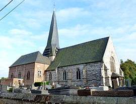 The church in Auppegard | |
 Auppegard Location within Normandy region  Auppegard | |
| Coordinates: 49°49′49″N 1°01′50″E / 49.8303°N 1.0306°ECoordinates: 49°49′49″N 1°01′50″E / 49.8303°N 1.0306°E | |
| Country | France |
| Region | Normandy |
| Department | Seine-Maritime |
| Arrondissement | Dieppe |
| Canton | Luneray |
| Intercommunality | CC Terroir Caux |
| Government | |
| • Mayor (2014-2020) | Jacques Deprez |
| Area1 | 7.33 km2 (2.83 sq mi) |
| Population (2015)2 | 731 |
| • Density | 100/km2 (260/sq mi) |
| Time zone | UTC+1 (CET) |
| • Summer (DST) | UTC+2 (CEST) |
| INSEE/Postal code | 76036 /76730 |
| Elevation |
73–107 m (240–351 ft) (avg. 102 m or 335 ft) |
|
1 French Land Register data, which excludes lakes, ponds, glaciers > 1 km2 (0.386 sq mi or 247 acres) and river estuaries. 2 Population without double counting: residents of multiple communes (e.g., students and military personnel) only counted once. | |
Auppegard is a commune in the Seine-Maritime department in the Normandy region in northern France.
Geography
A farming village situated in the Pays de Caux, some 6 miles (9.7 km) south of Dieppe at the junction of the D108 and D308 roads.
Etymology
Appelgart 1160; Anglo-Norse place name æppel > apple and gardr > yard, garden. Like Applegarth (Yorkshire, Appelgard 1160 ) and Épégard (Eure, Alpegard 1199 ).
It shows, that apples have been grown in Normandy for a long time, probably already to make cider.
Population
| Year | 1962 | 1968 | 1975 | 1982 | 1990 | 1999 | 2006 | 2015 |
|---|---|---|---|---|---|---|---|---|
| Population | 393 | 422 | 468 | 523 | 551 | 561 | 673 | 731 |
| From the year 1962 on: No double counting—residents of multiple communes (e.g. students and military personnel) are counted only once. | ||||||||
Places of interest
- The sixteenth-century church of St.Pierre, with a twisted spire.
- The seventeenth-century château.
See also
References
External links
| Wikimedia Commons has media related to Auppegard. |
- Auppegard on the Quid website (in French)
This article is issued from
Wikipedia.
The text is licensed under Creative Commons - Attribution - Sharealike.
Additional terms may apply for the media files.