Vieux-Manoir
| Vieux-Manoir | ||
|---|---|---|
| Commune | ||
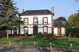 The town hall in Vieux-Manoir | ||
| ||
 Vieux-Manoir Location within Normandy region  Vieux-Manoir | ||
| Coordinates: 49°34′04″N 1°17′55″E / 49.5678°N 1.2986°ECoordinates: 49°34′04″N 1°17′55″E / 49.5678°N 1.2986°E | ||
| Country | France | |
| Region | Normandy | |
| Department | Seine-Maritime | |
| Arrondissement | Rouen | |
| Canton | Le Mesnil-Esnard | |
| Government | ||
| • Mayor (2008–2014) | Pierre Palenne | |
| Area1 | 8.13 km2 (3.14 sq mi) | |
| Population (2006)2 | 703 | |
| • Density | 86/km2 (220/sq mi) | |
| Time zone | UTC+1 (CET) | |
| • Summer (DST) | UTC+2 (CEST) | |
| INSEE/Postal code | 76738 /76750 | |
| Elevation |
143–189 m (469–620 ft) (avg. 173 m or 568 ft) | |
|
1 French Land Register data, which excludes lakes, ponds, glaciers > 1 km2 (0.386 sq mi or 247 acres) and river estuaries. 2 Population without double counting: residents of multiple communes (e.g., students and military personnel) only counted once. | ||

Vieux-Manoir is a commune in the Seine-Maritime department in the Normandy region in northern France.
Geography
A village of farming and associated light industry situated in the Pays de Bray, some 15 miles (24 km) northeast of Rouen near the junction of the D206 with the D122 road. The A28 autoroute forms the western border of the commune and SNCF operates a TER railway service here.
Population
| Year | 1962 | 1968 | 1975 | 1982 | 1990 | 1999 | 2006 |
|---|---|---|---|---|---|---|---|
| Population | 277 | 280 | 340 | 609 | 599 | 650 | 703 |
| From the year 1962 on: No double counting—residents of multiple communes (e.g. students and military personnel) are counted only once. | |||||||
Places of interest
- The church of Notre-Dame, dating from the sixteenth century.
See also
References
External links
| Wikimedia Commons has media related to Vieux-Manoir. |
- Vieux-Manoir on the Quid website (in French)
This article is issued from
Wikipedia.
The text is licensed under Creative Commons - Attribution - Sharealike.
Additional terms may apply for the media files.