Landes-Vieilles-et-Neuves
| Landes-Vieilles-et-Neuves | |
|---|---|
| Commune | |
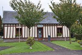 The town hall in Landes-Vieilles-et-Neuves | |
 Landes-Vieilles-et-Neuves Location within Normandy region  Landes-Vieilles-et-Neuves | |
| Coordinates: 49°47′16″N 1°37′49″E / 49.7878°N 1.6303°ECoordinates: 49°47′16″N 1°37′49″E / 49.7878°N 1.6303°E | |
| Country | France |
| Region | Normandy |
| Department | Seine-Maritime |
| Arrondissement | Dieppe |
| Canton | Gournay-en-Bray |
| Intercommunality | CC Aumale - Blangy-sur-Bresle |
| Government | |
| • Mayor (2008–2014) | Alain Blondin |
| Area1 | 7.09 km2 (2.74 sq mi) |
| Population (2006)2 | 128 |
| • Density | 18/km2 (47/sq mi) |
| Time zone | UTC+1 (CET) |
| • Summer (DST) | UTC+2 (CEST) |
| INSEE/Postal code | 76381 /76390 |
| Elevation |
169–230 m (554–755 ft) (avg. 210 m or 690 ft) |
|
1 French Land Register data, which excludes lakes, ponds, glaciers > 1 km2 (0.386 sq mi or 247 acres) and river estuaries. 2 Population without double counting: residents of multiple communes (e.g., students and military personnel) only counted once. | |
Landes-Vieilles-et-Neuves is a commune in the Seine-Maritime department in the Normandy region in northern France.
Geography
Landes-Vieilles-et-Neuves is a small farming village with four hamlets, situated in the Pays de Bray, some 45 kilometres (28 mi) southeast of Dieppe at the junction of the D82 and the D7 roads.
Population
| Year | 1962 | 1968 | 1975 | 1982 | 1990 | 1999 | 2006 |
|---|---|---|---|---|---|---|---|
| Population | 136 | 149 | 147 | 105 | 148 | 132 | 128 |
| From the year 1962 on: No double counting—residents of multiple communes (e.g. students and military personnel) are counted only once. | |||||||
Places of interest
- The chapel of St.Marguerite at Vieilles-Landes.
- The church of St.Lambert at Landes-Neuves, dating from the sixteenth century.
See also
References
External links
| Wikimedia Commons has media related to Landes-Vieilles-et-Neuves. |
- Landes-Vieilles-et-Neuves on the Quid website (in French)
This article is issued from
Wikipedia.
The text is licensed under Creative Commons - Attribution - Sharealike.
Additional terms may apply for the media files.