Saint-Honoré, Seine-Maritime
| Saint-Honoré | |
|---|---|
| Commune | |
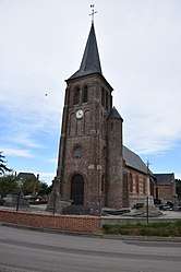 The church in Saint-Honoré | |
 Saint-Honoré Location within Normandy region  Saint-Honoré | |
| Coordinates: 49°47′05″N 1°09′26″E / 49.7847°N 1.1572°ECoordinates: 49°47′05″N 1°09′26″E / 49.7847°N 1.1572°E | |
| Country | France |
| Region | Normandy |
| Department | Seine-Maritime |
| Arrondissement | Dieppe |
| Canton | Luneray |
| Intercommunality | CC Terroir de Caux |
| Government | |
| • Mayor | Paul Potel |
| Area1 | 3.02 km2 (1.17 sq mi) |
| Population (2006)2 | 170 |
| • Density | 56/km2 (150/sq mi) |
| Time zone | UTC+1 (CET) |
| • Summer (DST) | UTC+2 (CEST) |
| INSEE/Postal code | 76589 /76590 |
| Elevation |
65–157 m (213–515 ft) (avg. 150 m or 490 ft) |
|
1 French Land Register data, which excludes lakes, ponds, glaciers > 1 km2 (0.386 sq mi or 247 acres) and river estuaries. 2 Population without double counting: residents of multiple communes (e.g., students and military personnel) only counted once. | |
Saint-Honoré is a commune in the Seine-Maritime department in the Normandy region in northern France.
Geography
A small farming village situated in the Pays de Caux, at the junction of the D100 and the D77 roads, some 9 miles (14 km) south of Dieppe.
Population
| 1962 | 1968 | 1975 | 1982 | 1990 | 1999 | 2006 |
|---|---|---|---|---|---|---|
| 89 | 102 | 118 | 176 | 167 | 172 | 170 |
| Starting in 1962: Population without duplicates | ||||||
Places of interest
- The church of St.Honoré, dating from the eighteenth century.
- A sixteenth century sandstone cross.
See also
References
External links
| Wikimedia Commons has media related to Saint-Honoré (Seine-Maritime). |
- Saint-Honoré on the Quid website (in French)
This article is issued from
Wikipedia.
The text is licensed under Creative Commons - Attribution - Sharealike.
Additional terms may apply for the media files.