Drosay
| Drosay | ||
|---|---|---|
| Commune | ||
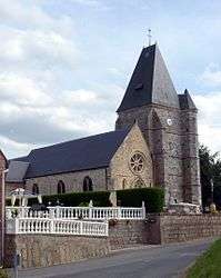 The church in Drosay | ||
| ||
 Drosay Location within Normandy region  Drosay | ||
| Coordinates: 49°47′42″N 0°44′29″E / 49.795°N 0.7414°ECoordinates: 49°47′42″N 0°44′29″E / 49.795°N 0.7414°E | ||
| Country | France | |
| Region | Normandy | |
| Department | Seine-Maritime | |
| Arrondissement | Dieppe | |
| Canton | Saint-Valery-en-Caux | |
| Intercommunality | CC Côte d'Albâtre | |
| Government | ||
| • Mayor | Jacques Lefrancois | |
| Area1 | 6.43 km2 (2.48 sq mi) | |
| Population (2007)2 | 225 | |
| • Density | 35/km2 (91/sq mi) | |
| Time zone | UTC+1 (CET) | |
| • Summer (DST) | UTC+2 (CEST) | |
| INSEE/Postal code | 76221 /76460 | |
| Elevation |
63–129 m (207–423 ft) (avg. 100 m or 330 ft) | |
|
1 French Land Register data, which excludes lakes, ponds, glaciers > 1 km2 (0.386 sq mi or 247 acres) and river estuaries. 2 Population without double counting: residents of multiple communes (e.g., students and military personnel) only counted once. | ||
.svg.png)
Drosay is a commune in the Seine-Maritime department in the Normandy region in northern France.
Geography
A small farming village situated in the Pays de Caux, some 25 miles (40 km) southwest of Dieppe, at the junction of the D75, D108 and the D107 roads.
Population
| Year | 1962 | 1968 | 1975 | 1982 | 1990 | 1999 | 2006 | 2007 |
|---|---|---|---|---|---|---|---|---|
| Population | 161 | 203 | 169 | 193 | 174 | 186 | 216 | 225 |
| From the year 1962 on: No double counting—residents of multiple communes (e.g. students and military personnel) are counted only once. | ||||||||
In 2007, the number of housing units in Drosay was 104. Of these, 83 were main residences, 20 were secondary homes, and 1 was vacant.[1]
Places of interest
- The church of St.Martin, dating from the thirteenth century.
- The chapel of St.Roch, dating from the eleventh century.
See also
References
- ↑ "Town of Drosay". Map-France. Retrieved 9 June 2015.
External links
| Wikimedia Commons has media related to Drosay. |
- Drosay on the Quid website (in French)
This article is issued from
Wikipedia.
The text is licensed under Creative Commons - Attribution - Sharealike.
Additional terms may apply for the media files.