Mésangueville
| Mésangueville | ||
|---|---|---|
| Commune | ||
| ||
 Mésangueville Location within Normandy region  Mésangueville | ||
| Coordinates: 49°32′49″N 1°33′36″E / 49.5469°N 1.56°ECoordinates: 49°32′49″N 1°33′36″E / 49.5469°N 1.56°E | ||
| Country | France | |
| Region | Normandy | |
| Department | Seine-Maritime | |
| Arrondissement | Dieppe | |
| Canton | Gournay-en-Bray | |
| Intercommunality | CC 4 rivières | |
| Government | ||
| • Mayor | Gilbert Coutard | |
| Area1 | 10.55 km2 (4.07 sq mi) | |
| Population (2006)2 | 153 | |
| • Density | 15/km2 (38/sq mi) | |
| Time zone | UTC+1 (CET) | |
| • Summer (DST) | UTC+2 (CEST) | |
| INSEE/Postal code | 76426 /76780 | |
| Elevation |
114–185 m (374–607 ft) (avg. 160 m or 520 ft) | |
|
1 French Land Register data, which excludes lakes, ponds, glaciers > 1 km2 (0.386 sq mi or 247 acres) and river estuaries. 2 Population without double counting: residents of multiple communes (e.g., students and military personnel) only counted once. | ||
Mésangueville is a commune in the Seine-Maritime department in the Normandy region in northern France.
Geography
A small forestry and farming village situated in the valley of the river Epte in the Pays de Bray, some 23 miles (37 km) northeast of Rouen at the junction of the D128 with the D41.
Heraldry
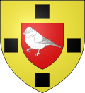 |
The arms of Mésangueville are blazoned : Or, on an inescutcheon, a tit argent, all between 4 lozenges 1,2,1 sable. (these lozenges are rotated squares) |
Population
| 1962 | 1968 | 1975 | 1982 | 1990 | 1999 | 2006 |
|---|---|---|---|---|---|---|
| 192 | 201 | 161 | 137 | 137 | 143 | 153 |
| Starting in 1962: Population without duplicates | ||||||
Places of interest
- The church of St.Nicolas, dating from the thirteenth century.
See also
References
External links
| Wikimedia Commons has media related to Mésangueville. |
- Mésangueville on the Quid website (in French)
This article is issued from
Wikipedia.
The text is licensed under Creative Commons - Attribution - Sharealike.
Additional terms may apply for the media files.