Bosc-Édeline
| Bosc-Édeline | |
|---|---|
| Commune | |
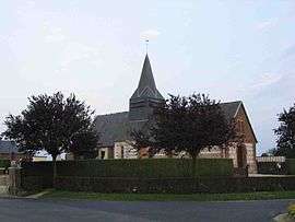 The church in Bosc-Édeline | |
 Bosc-Édeline Location within Normandy region  Bosc-Édeline | |
| Coordinates: 49°34′16″N 1°25′38″E / 49.5711°N 1.4272°ECoordinates: 49°34′16″N 1°25′38″E / 49.5711°N 1.4272°E | |
| Country | France |
| Region | Normandy |
| Department | Seine-Maritime |
| Arrondissement | Rouen |
| Canton | Le Mesnil-Esnard |
| Government | |
| • Mayor | Cécile Brument |
| Area1 | 6.19 km2 (2.39 sq mi) |
| Population (2006)2 | 308 |
| • Density | 50/km2 (130/sq mi) |
| Time zone | UTC+1 (CET) |
| • Summer (DST) | UTC+2 (CEST) |
| INSEE/Postal code | 76121 /76750 |
| Elevation |
168–232 m (551–761 ft) (avg. 226 m or 741 ft) |
|
1 French Land Register data, which excludes lakes, ponds, glaciers > 1 km2 (0.386 sq mi or 247 acres) and river estuaries. 2 Population without double counting: residents of multiple communes (e.g., students and military personnel) only counted once. | |
Bosc-Édeline is a commune in the Seine-Maritime department in the Normandy region in northern France.
Geography
A farming village situated in the Pays de Bray some 19 miles (31 km) northeast of Rouen, at the junction of the D61 and the D38 roads.
Population
| Year | 1962 | 1968 | 1975 | 1982 | 1990 | 1999 | 2006 |
|---|---|---|---|---|---|---|---|
| Population | 172 | 189 | 182 | 246 | 257 | 284 | 308 |
| From the year 1962 on: No double counting—residents of multiple communes (e.g. students and military personnel) are counted only once. | |||||||
Places of interest
- The church of the Trinity, dating from the thirteenth century.
See also
References
External links
| Wikimedia Commons has media related to Bosc-Édeline. |
- Bosc-Édeline on the Quid website (in French)
This article is issued from
Wikipedia.
The text is licensed under Creative Commons - Attribution - Sharealike.
Additional terms may apply for the media files.