Saint-Aubin-sur-Scie
| Saint-Aubin-sur-Scie | ||
|---|---|---|
| Commune | ||
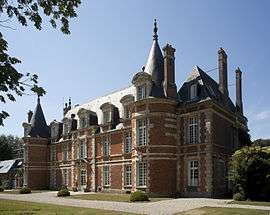 The chateau of Miromesnil | ||
| ||
 Saint-Aubin-sur-Scie Location within Normandy region  Saint-Aubin-sur-Scie | ||
| Coordinates: 49°52′20″N 1°04′16″E / 49.8722°N 1.0711°ECoordinates: 49°52′20″N 1°04′16″E / 49.8722°N 1.0711°E | ||
| Country | France | |
| Region | Normandy | |
| Department | Seine-Maritime | |
| Arrondissement | Dieppe | |
| Canton | Dieppe-1 | |
| Intercommunality | CA Région Dieppoise | |
| Government | ||
| • Mayor | Bernard Bazille | |
| Area1 | 7.74 km2 (2.99 sq mi) | |
| Population (2006)2 | 1,302 | |
| • Density | 170/km2 (440/sq mi) | |
| Time zone | UTC+1 (CET) | |
| • Summer (DST) | UTC+2 (CEST) | |
| INSEE/Postal code | 76565 /76550 | |
| Elevation |
9–105 m (30–344 ft) (avg. 20 m or 66 ft) | |
|
1 French Land Register data, which excludes lakes, ponds, glaciers > 1 km2 (0.386 sq mi or 247 acres) and river estuaries. 2 Population without double counting: residents of multiple communes (e.g., students and military personnel) only counted once. | ||
Saint-Aubin-sur-Scie is a commune in the Seine-Maritime department in the Normandy region in northern France.
Geography
A farming village situated by the banks of the river Scie in the Pays de Caux, at the junction of the D54 and the N 27 roads, some 5 miles (8.0 km) south of Dieppe.
Heraldry
 |
The arms of Saint-Aubin-sur-Scie are blazoned : Vert, a fess argent between 2 mill wheels and a 3 stalks of wheat slipped and leaved, tied, Or. |
Population
| 1962 | 1968 | 1975 | 1982 | 1990 | 1999 | 2006 |
|---|---|---|---|---|---|---|
| 832 | 861 | 966 | 1087 | 1111 | 1120 | 1302 |
| Starting in 1962: Population without duplicates | ||||||
Places of interest
- The seventeenth-century chateau of Miromesnil.
- A seventeenth-century chapel.
- The church of St. Aubin, dating from the thirteenth century.
- The chapel of St. Antoine, dating from the sixteenth century.
See also
References
External links
| Wikimedia Commons has media related to Saint-Aubin-sur-Scie. |
- Official commune website (in French)
- Saint-Aubin-sur-Scie on the Quid website (in French)
This article is issued from
Wikipedia.
The text is licensed under Creative Commons - Attribution - Sharealike.
Additional terms may apply for the media files.