Bourville
| Bourville | |
|---|---|
| Commune | |
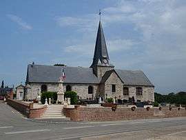 The church in Bourville | |
 Bourville Location within Normandy region  Bourville | |
| Coordinates: 49°47′44″N 0°49′15″E / 49.7956°N 0.8208°ECoordinates: 49°47′44″N 0°49′15″E / 49.7956°N 0.8208°E | |
| Country | France |
| Region | Normandy |
| Department | Seine-Maritime |
| Arrondissement | Dieppe |
| Canton | Saint-Valery-en-Caux |
| Intercommunality | CC Côte d'Albâtre |
| Government | |
| • Mayor (2008–2014) | Didier Boullard |
| Area1 | 6.61 km2 (2.55 sq mi) |
| Population (2006)2 | 298 |
| • Density | 45/km2 (120/sq mi) |
| Time zone | UTC+1 (CET) |
| • Summer (DST) | UTC+2 (CEST) |
| INSEE/Postal code | 76134 /76740 |
| Elevation |
63–114 m (207–374 ft) (avg. 90 m or 300 ft) |
|
1 French Land Register data, which excludes lakes, ponds, glaciers > 1 km2 (0.386 sq mi or 247 acres) and river estuaries. 2 Population without double counting: residents of multiple communes (e.g., students and military personnel) only counted once. | |
Bourville is a commune in the Seine-Maritime department in the Normandy region in northern France.
Geography
A farming village situated in the Pays de Caux, some 20 miles (32 km) southwest of Dieppe, at the junction of the D108 and the D237 roads.
Population
| Year | 1962 | 1968 | 1975 | 1982 | 1990 | 1999 | 2006 |
|---|---|---|---|---|---|---|---|
| Population | 409 | 433 | 373 | 410 | 318 | 313 | 298 |
| From the year 1962 on: No double counting—residents of multiple communes (e.g. students and military personnel) are counted only once. | |||||||
Places of interest
- The church of St. Martin, dating from the twelfth century.
- The seventeenth-century chateau de Tonneville.
- The seventeenth-century church at Tonneville.
Notable people
- Actor Bourvil (André Raimbourg) spent all his childhood in the village and its name inspired his stage name.
See also
References
External links
| Wikimedia Commons has media related to Bourville. |
- Bourville on the Quid website (in French)
This article is issued from
Wikipedia.
The text is licensed under Creative Commons - Attribution - Sharealike.
Additional terms may apply for the media files.