Fry, Seine-Maritime
| Fry | |
|---|---|
| Commune | |
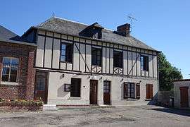 The town hall in Fry | |
 Fry Location within Normandy region  Fry | |
| Coordinates: 49°31′50″N 1°31′40″E / 49.5306°N 1.5278°ECoordinates: 49°31′50″N 1°31′40″E / 49.5306°N 1.5278°E | |
| Country | France |
| Region | Normandy |
| Department | Seine-Maritime |
| Arrondissement | Dieppe |
| Canton | Gournay-en-Bray |
| Intercommunality | CC 4 rivières |
| Government | |
| • Mayor | François-Mary Noel |
| Area1 | 8.03 km2 (3.10 sq mi) |
| Population (2006)2 | 139 |
| • Density | 17/km2 (45/sq mi) |
| Time zone | UTC+1 (CET) |
| • Summer (DST) | UTC+2 (CEST) |
| INSEE/Postal code | 76292 /76780 |
| Elevation |
108–216 m (354–709 ft) (avg. 118 m or 387 ft) |
|
1 French Land Register data, which excludes lakes, ponds, glaciers > 1 km2 (0.386 sq mi or 247 acres) and river estuaries. 2 Population without double counting: residents of multiple communes (e.g., students and military personnel) only counted once. | |
Fry is a commune in the Seine-Maritime department in the Normandy region in northern France.
Geography
A small farming village situated in the Pays de Bray, some 20 miles (32 km) northeast of Rouen, at the junction of the D1, D128 and the D921 roads.
Population
| Year | 1962 | 1968 | 1975 | 1982 | 1990 | 1999 | 2005 |
|---|---|---|---|---|---|---|---|
| Population | 162 | 167 | 150 | 123 | 133 | 136 | 139 |
| From the year 1962 on: No double counting—residents of multiple communes (e.g. students and military personnel) are counted only once. | |||||||
Places of interest
- The thirteenth century church of St.Martin.
- A presbytery dating from the seventeenth century.
See also
References
External links
| Wikimedia Commons has media related to Fry (Seine-Maritime). |
- Fry on the Quid website (in French)
This article is issued from
Wikipedia.
The text is licensed under Creative Commons - Attribution - Sharealike.
Additional terms may apply for the media files.