Ganzeville
| Ganzeville | ||
|---|---|---|
| Commune | ||
| ||
 Ganzeville Location within Normandy region  Ganzeville | ||
| Coordinates: 49°44′09″N 0°24′45″E / 49.7358°N 0.4125°ECoordinates: 49°44′09″N 0°24′45″E / 49.7358°N 0.4125°E | ||
| Country | France | |
| Region | Normandy | |
| Department | Seine-Maritime | |
| Arrondissement | Le Havre | |
| Canton | Fécamp | |
| Intercommunality | CA Fécamp Caux Littoral | |
| Government | ||
| • Mayor (2001–2008) | Jean-Marie Crochemore | |
| Area1 | 3.96 km2 (1.53 sq mi) | |
| Population (2006)2 | 456 | |
| • Density | 120/km2 (300/sq mi) | |
| Time zone | UTC+1 (CET) | |
| • Summer (DST) | UTC+2 (CEST) | |
| INSEE/Postal code | 76298 /76400 | |
| Elevation |
16–122 m (52–400 ft) (avg. 32 m or 105 ft) | |
|
1 French Land Register data, which excludes lakes, ponds, glaciers > 1 km2 (0.386 sq mi or 247 acres) and river estuaries. 2 Population without double counting: residents of multiple communes (e.g., students and military personnel) only counted once. | ||
Ganzeville is a commune in the Seine-Maritime department in the Normandy region in northern France.
Geography
A farming village situated in the Pays de Caux, some 24 miles (39 km) northeast of Le Havre, near the junction of the D28 and D68 roads.
Heraldry
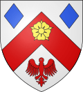 |
The arms of Ganzeville are blazoned : Argent, on a chevron gules between 2 lozenges azure and an alerion gules, a rose Or. |
Population
| Year | 1962 | 1968 | 1975 | 1982 | 1990 | 1999 | 2006 |
|---|---|---|---|---|---|---|---|
| Population | 510 | 459 | 416 | 467 | 404 | 442 | 456 |
| From the year 1962 on: No double counting—residents of multiple communes (e.g. students and military personnel) are counted only once. | |||||||
Places of interest
See also
References
External links
| Wikimedia Commons has media related to Ganzeville. |
- Ganzeville on the Quid website (in French)
This article is issued from
Wikipedia.
The text is licensed under Creative Commons - Attribution - Sharealike.
Additional terms may apply for the media files.