Moulineaux
| Moulineaux | ||
|---|---|---|
| Commune | ||
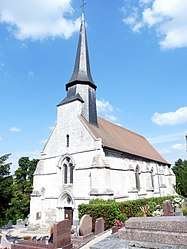 The church in Moulineaux | ||
| ||
 Moulineaux Location within Normandy region  Moulineaux | ||
| Coordinates: 49°20′35″N 0°58′00″E / 49.34306°N 0.96667°ECoordinates: 49°20′35″N 0°58′00″E / 49.34306°N 0.96667°E | ||
| Country | France | |
| Region | Normandy | |
| Department | Seine-Maritime | |
| Arrondissement | Rouen | |
| Canton | Elbeuf | |
| Intercommunality | Métropole Rouen Normandie | |
| Government | ||
| • Mayor (2007 - 2008) | Martine Tailliandier | |
| Area1 | 3.47 km2 (1.34 sq mi) | |
| Population (2006)2 | 903 | |
| • Density | 260/km2 (670/sq mi) | |
| Time zone | UTC+1 (CET) | |
| • Summer (DST) | UTC+2 (CEST) | |
| INSEE/Postal code | 76457 /76530 | |
| Elevation |
2–125 m (6.6–410.1 ft) (avg. 6 m or 20 ft) | |
|
1 French Land Register data, which excludes lakes, ponds, glaciers > 1 km2 (0.386 sq mi or 247 acres) and river estuaries. 2 Population without double counting: residents of multiple communes (e.g., students and military personnel) only counted once. | ||
.svg.png)
Moulineaux is a commune in the Seine-Maritime department in the Normandy region in northern France.
Geography
A village of light industry and forestry situated by the banks of the river Seine, some 10 miles (16 km) southwest of Rouen at the junction of the D3, D64 and the D67 roads. The A13 autoroute passes through the commune’s territory.
Population
| 1962 | 1968 | 1975 | 1982 | 1990 | 1999 | 2006 |
|---|---|---|---|---|---|---|
| 462 | 843 | 973 | 838 | 792 | 890 | 903 |
| Starting in 1962: Population without duplicates | ||||||
Places of interest
- The church of St. Jacques, dating from the thirteenth century.
- Remains of the eleventh-century castle of Robert le Diable, also housing a museum.
- The Caradas manorhouse and St. Jean’s chapel at Fontaines.
- A sixteenth century chapel.
- The Château de La Vacherie, dating from the seventeenth century.
See also
References
External links
| Wikimedia Commons has media related to Moulineaux. |
- Photos of the château de Robert le Diable (in French)
- Moulineaux on the Quid website (in French)
This article is issued from
Wikipedia.
The text is licensed under Creative Commons - Attribution - Sharealike.
Additional terms may apply for the media files.